You are here: Home > Network List > TA - USArray Transportable Network (new EarthScope stations) Stations List
> Station L20K Farewell, AK, USA > Earthquake Result Viewer
L20K Farewell, AK, USA - Earthquake Result Viewer
| Earthquake location: |
Vanuatu Islands |
| Earthquake latitude/longitude: |
-16.1/167.4 |
| Earthquake time(UTC): |
2016/06/30 (182) 11:30:34 GMT |
| Earthquake Depth: |
40 km |
| Earthquake Magnitude: |
5.8 MB |
| Earthquake Catalog/Contributor: |
NEIC PDE/NEIC COMCAT |
|
| Network: |
TA USArray Transportable Network (new EarthScope stations) |
| Station: |
L20K Farewell, AK, USA |
| Lat/Lon: |
62.48 N/153.88 W |
| Elevation: |
673 m |
|
| Distance: |
84.0 deg |
| Az: |
16.98 deg |
| Baz: |
217.182 deg |
| Ray Param: |
0.045730986 |
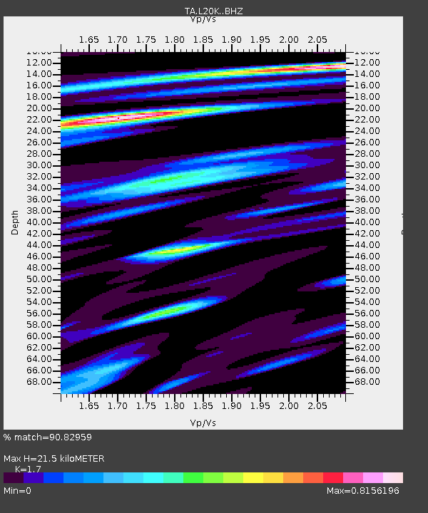
| Estimated Moho Depth: |
21.5 km |
| Estimated Crust Vp/Vs: |
1.70 |
| Assumed Crust Vp: |
6.566 km/s |
| Estimated Crust Vs: |
3.862 km/s |
| Estimated Crust Poisson's Ratio: |
0.24 |
|
| Radial Match: |
90.82959 % |
| Radial Bump: |
400 |
| Transverse Match: |
85.74312 % |
| Transverse Bump: |
400 |
| SOD ConfigId: |
11737051 |
| Insert Time: |
2019-04-25 00:23:32.598 +0000 |
| GWidth: |
2.5 |
| Max Bumps: |
400 |
| Tol: |
0.001 |
|
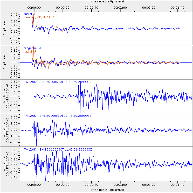
Signal To Noise
| Channel | StoN | STA | LTA |
| TA:L20K: :BHZ:20160630T11:42:29.299993Z | 15.544343 | 9.530273E-7 | 6.131024E-8 |
| TA:L20K: :BHN:20160630T11:42:29.299993Z | 7.544908 | 3.0979973E-7 | 4.106077E-8 |
| TA:L20K: :BHE:20160630T11:42:29.299993Z | 5.6006384 | 2.8557483E-7 | 5.0989694E-8 |
| Arrivals |
| Ps | 2.4 SECOND |
| PpPs | 8.6 SECOND |
| PsPs/PpSs | 11 SECOND |


