You are here: Home > Network List > US - United States National Seismic Network Stations List
> Station HLID Hailey, Idaho, USA > Earthquake Result Viewer
HLID Hailey, Idaho, USA - Earthquake Result Viewer
| Earthquake location: |
Southern Peru |
| Earthquake latitude/longitude: |
-15.3/-73.0 |
| Earthquake time(UTC): |
2005/07/26 (207) 14:11:36 GMT |
| Earthquake Depth: |
110 km |
| Earthquake Magnitude: |
5.8 MB, 6.0 MW, 5.9 MW |
| Earthquake Catalog/Contributor: |
WHDF/NEIC |
|
| Network: |
US United States National Seismic Network |
| Station: |
HLID Hailey, Idaho, USA |
| Lat/Lon: |
43.56 N/114.41 W |
| Elevation: |
1772 m |
|
| Distance: |
69.8 deg |
| Az: |
329.155 deg |
| Baz: |
137.118 deg |
| Ray Param: |
0.05511353 |
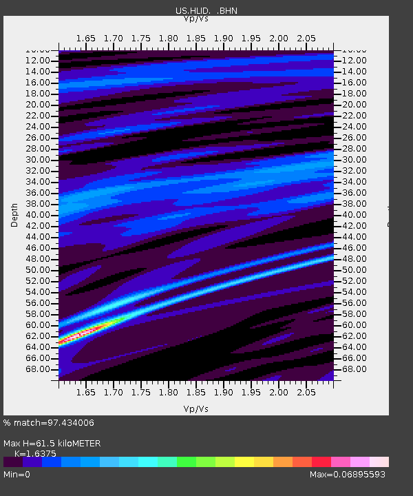
| Estimated Moho Depth: |
61.5 km |
| Estimated Crust Vp/Vs: |
1.64 |
| Assumed Crust Vp: |
6.291 km/s |
| Estimated Crust Vs: |
3.842 km/s |
| Estimated Crust Poisson's Ratio: |
0.20 |
|
| Radial Match: |
97.434006 % |
| Radial Bump: |
95 |
| Transverse Match: |
95.68739 % |
| Transverse Bump: |
102 |
| SOD ConfigId: |
2669 |
| Insert Time: |
2010-03-05 05:03:52.842 +0000 |
| GWidth: |
2.5 |
| Max Bumps: |
400 |
| Tol: |
0.001 |
|

Signal To Noise
| Channel | StoN | STA | LTA |
| US:HLID: :BHN:20050726T14:22:04.082017Z | 0.9596948 | 5.665274E-10 | 5.903204E-10 |
| US:HLID: :BHE:20050726T14:22:04.082017Z | 0.97364587 | 6.149614E-10 | 6.316069E-10 |
| US:HLID: :BHZ:20050726T14:22:04.082017Z | 1.0923526 | 5.696945E-10 | 5.215299E-10 |
| Arrivals |
| Ps | 6.5 SECOND |
| PpPs | 25 SECOND |
| PsPs/PpSs | 31 SECOND |


