You are here: Home > Network List > TA - USArray Transportable Network (new EarthScope stations) Stations List
> Station E22K Anaktuvuk Pass, AK, USA > Earthquake Result Viewer
E22K Anaktuvuk Pass, AK, USA - Earthquake Result Viewer
| Earthquake location: |
Santa Cruz Islands Region |
| Earthquake latitude/longitude: |
-10.6/165.0 |
| Earthquake time(UTC): |
2016/07/04 (186) 09:25:41 GMT |
| Earthquake Depth: |
67 km |
| Earthquake Magnitude: |
5.6 MB |
| Earthquake Catalog/Contributor: |
NEIC PDE/NEIC COMCAT |
|
| Network: |
TA USArray Transportable Network (new EarthScope stations) |
| Station: |
E22K Anaktuvuk Pass, AK, USA |
| Lat/Lon: |
68.13 N/151.81 W |
| Elevation: |
772 m |
|
| Distance: |
84.4 deg |
| Az: |
14.936 deg |
| Baz: |
222.561 deg |
| Ray Param: |
0.045411035 |
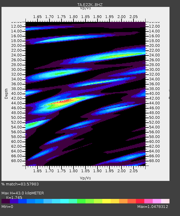
| Estimated Moho Depth: |
43.0 km |
| Estimated Crust Vp/Vs: |
1.75 |
| Assumed Crust Vp: |
6.221 km/s |
| Estimated Crust Vs: |
3.565 km/s |
| Estimated Crust Poisson's Ratio: |
0.26 |
|
| Radial Match: |
83.57983 % |
| Radial Bump: |
400 |
| Transverse Match: |
84.40116 % |
| Transverse Bump: |
400 |
| SOD ConfigId: |
11737051 |
| Insert Time: |
2019-04-25 00:30:26.505 +0000 |
| GWidth: |
2.5 |
| Max Bumps: |
400 |
| Tol: |
0.001 |
|

Signal To Noise
| Channel | StoN | STA | LTA |
| TA:E22K: :BHZ:20160704T09:37:35.800Z | 5.8198647 | 2.7222495E-7 | 4.677513E-8 |
| TA:E22K: :BHN:20160704T09:37:35.800Z | 3.947555 | 1.395014E-7 | 3.5338683E-8 |
| TA:E22K: :BHE:20160704T09:37:35.800Z | 1.9739242 | 5.7892144E-8 | 2.9328454E-8 |
| Arrivals |
| Ps | 5.3 SECOND |
| PpPs | 19 SECOND |
| PsPs/PpSs | 24 SECOND |


