You are here: Home > Network List > TA - USArray Transportable Network (new EarthScope stations) Stations List
> Station H23K Yukon River, AK, USA > Earthquake Result Viewer
H23K Yukon River, AK, USA - Earthquake Result Viewer
| Earthquake location: |
Santa Cruz Islands Region |
| Earthquake latitude/longitude: |
-10.6/165.0 |
| Earthquake time(UTC): |
2016/07/04 (186) 09:25:41 GMT |
| Earthquake Depth: |
67 km |
| Earthquake Magnitude: |
5.6 MB |
| Earthquake Catalog/Contributor: |
NEIC PDE/NEIC COMCAT |
|
| Network: |
TA USArray Transportable Network (new EarthScope stations) |
| Station: |
H23K Yukon River, AK, USA |
| Lat/Lon: |
65.83 N/149.54 W |
| Elevation: |
617 m |
|
| Distance: |
83.3 deg |
| Az: |
17.197 deg |
| Baz: |
224.892 deg |
| Ray Param: |
0.046156686 |
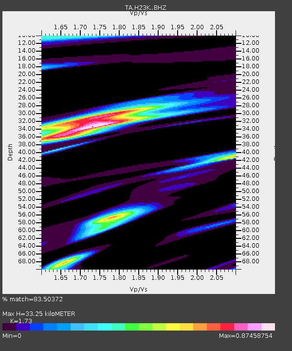
| Estimated Moho Depth: |
33.25 km |
| Estimated Crust Vp/Vs: |
1.73 |
| Assumed Crust Vp: |
6.566 km/s |
| Estimated Crust Vs: |
3.795 km/s |
| Estimated Crust Poisson's Ratio: |
0.25 |
|
| Radial Match: |
83.50372 % |
| Radial Bump: |
387 |
| Transverse Match: |
84.73646 % |
| Transverse Bump: |
359 |
| SOD ConfigId: |
11737051 |
| Insert Time: |
2019-04-25 00:30:34.216 +0000 |
| GWidth: |
2.5 |
| Max Bumps: |
400 |
| Tol: |
0.001 |
|

Signal To Noise
| Channel | StoN | STA | LTA |
| TA:H23K: :BHZ:20160704T09:37:30.399976Z | 3.7979615 | 2.5432328E-7 | 6.69631E-8 |
| TA:H23K: :BHN:20160704T09:37:30.399976Z | 2.5524294 | 1.00232576E-7 | 3.926948E-8 |
| TA:H23K: :BHE:20160704T09:37:30.399976Z | 1.8625237 | 8.6127685E-8 | 4.6242466E-8 |
| Arrivals |
| Ps | 3.8 SECOND |
| PpPs | 13 SECOND |
| PsPs/PpSs | 17 SECOND |


