You are here: Home > Network List > TA - USArray Transportable Network (new EarthScope stations) Stations List
> Station J26L Joseph Creek, AK, USA > Earthquake Result Viewer
J26L Joseph Creek, AK, USA - Earthquake Result Viewer
| Earthquake location: |
Santa Cruz Islands Region |
| Earthquake latitude/longitude: |
-10.6/165.0 |
| Earthquake time(UTC): |
2016/07/04 (186) 09:25:41 GMT |
| Earthquake Depth: |
67 km |
| Earthquake Magnitude: |
5.6 MB |
| Earthquake Catalog/Contributor: |
NEIC PDE/NEIC COMCAT |
|
| Network: |
TA USArray Transportable Network (new EarthScope stations) |
| Station: |
J26L Joseph Creek, AK, USA |
| Lat/Lon: |
64.50 N/143.56 W |
| Elevation: |
1144 m |
|
| Distance: |
84.3 deg |
| Az: |
19.894 deg |
| Baz: |
230.605 deg |
| Ray Param: |
0.045470662 |
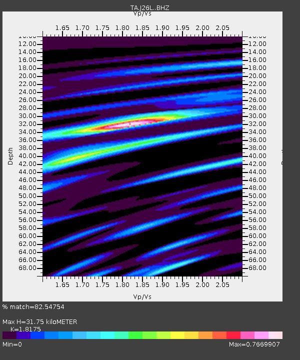
| Estimated Moho Depth: |
31.75 km |
| Estimated Crust Vp/Vs: |
1.82 |
| Assumed Crust Vp: |
6.566 km/s |
| Estimated Crust Vs: |
3.613 km/s |
| Estimated Crust Poisson's Ratio: |
0.28 |
|
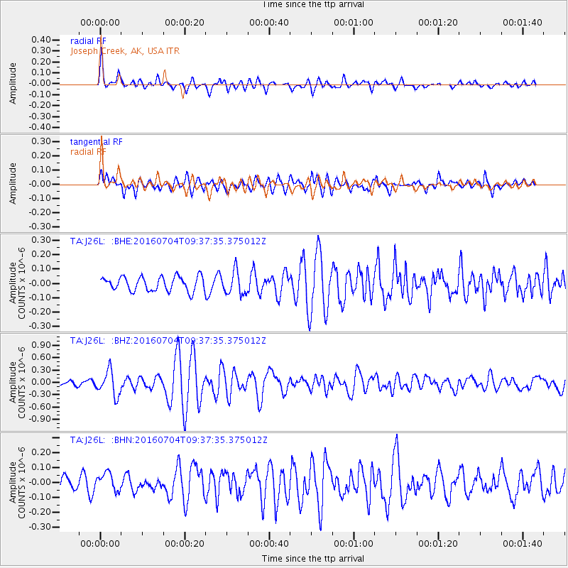
| Radial Match: |
82.54754 % |
| Radial Bump: |
400 |
| Transverse Match: |
61.7566 % |
| Transverse Bump: |
400 |
| SOD ConfigId: |
11737051 |
| Insert Time: |
2019-04-25 00:30:41.275 +0000 |
| GWidth: |
2.5 |
| Max Bumps: |
400 |
| Tol: |
0.001 |
|
Signal To Noise
| Channel | StoN | STA | LTA |
| TA:J26L: :BHZ:20160704T09:37:35.375012Z | 6.009254 | 3.0883393E-7 | 5.139306E-8 |
| TA:J26L: :BHN:20160704T09:37:35.375012Z | 1.1961018 | 6.427825E-8 | 5.3739782E-8 |
| TA:J26L: :BHE:20160704T09:37:35.375012Z | 1.6779494 | 8.239713E-8 | 4.9105847E-8 |
| Arrivals |
| Ps | 4.1 SECOND |
| PpPs | 13 SECOND |
| PsPs/PpSs | 17 SECOND |


