You are here: Home > Network List > TA - USArray Transportable Network (new EarthScope stations) Stations List
> Station L20K Farewell, AK, USA > Earthquake Result Viewer
L20K Farewell, AK, USA - Earthquake Result Viewer
| Earthquake location: |
Santa Cruz Islands Region |
| Earthquake latitude/longitude: |
-10.6/165.0 |
| Earthquake time(UTC): |
2016/07/04 (186) 09:25:41 GMT |
| Earthquake Depth: |
67 km |
| Earthquake Magnitude: |
5.6 MB |
| Earthquake Catalog/Contributor: |
NEIC PDE/NEIC COMCAT |
|
| Network: |
TA USArray Transportable Network (new EarthScope stations) |
| Station: |
L20K Farewell, AK, USA |
| Lat/Lon: |
62.48 N/153.88 W |
| Elevation: |
673 m |
|
| Distance: |
79.5 deg |
| Az: |
18.108 deg |
| Baz: |
221.128 deg |
| Ray Param: |
0.048752323 |
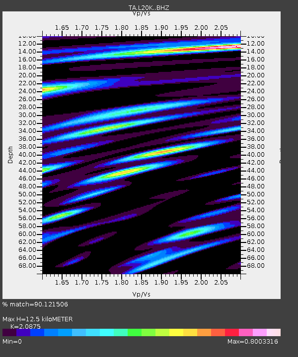
| Estimated Moho Depth: |
12.5 km |
| Estimated Crust Vp/Vs: |
2.09 |
| Assumed Crust Vp: |
6.566 km/s |
| Estimated Crust Vs: |
3.145 km/s |
| Estimated Crust Poisson's Ratio: |
0.35 |
|
| Radial Match: |
90.121506 % |
| Radial Bump: |
400 |
| Transverse Match: |
80.937256 % |
| Transverse Bump: |
400 |
| SOD ConfigId: |
11737051 |
| Insert Time: |
2019-04-25 00:30:45.571 +0000 |
| GWidth: |
2.5 |
| Max Bumps: |
400 |
| Tol: |
0.001 |
|

Signal To Noise
| Channel | StoN | STA | LTA |
| TA:L20K: :BHZ:20160704T09:37:10.625012Z | 12.171123 | 4.5072824E-7 | 3.7032596E-8 |
| TA:L20K: :BHN:20160704T09:37:10.625012Z | 4.336052 | 1.7791137E-7 | 4.103073E-8 |
| TA:L20K: :BHE:20160704T09:37:10.625012Z | 2.9715204 | 1.3610928E-7 | 4.580459E-8 |
| Arrivals |
| Ps | 2.1 SECOND |
| PpPs | 5.7 SECOND |
| PsPs/PpSs | 7.9 SECOND |


