You are here: Home > Network List > TA - USArray Transportable Network (new EarthScope stations) Stations List
> Station M19K Big River Lodge, Big River, AK, USA > Earthquake Result Viewer
M19K Big River Lodge, Big River, AK, USA - Earthquake Result Viewer
| Earthquake location: |
Santa Cruz Islands Region |
| Earthquake latitude/longitude: |
-10.6/165.0 |
| Earthquake time(UTC): |
2016/07/04 (186) 09:25:41 GMT |
| Earthquake Depth: |
67 km |
| Earthquake Magnitude: |
5.6 MB |
| Earthquake Catalog/Contributor: |
NEIC PDE/NEIC COMCAT |
|
| Network: |
TA USArray Transportable Network (new EarthScope stations) |
| Station: |
M19K Big River Lodge, Big River, AK, USA |
| Lat/Lon: |
61.90 N/154.39 W |
| Elevation: |
521 m |
|
| Distance: |
79.0 deg |
| Az: |
18.308 deg |
| Baz: |
220.713 deg |
| Ray Param: |
0.049157735 |
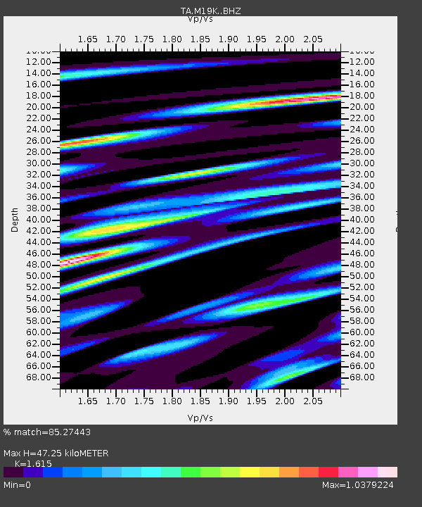
| Estimated Moho Depth: |
47.25 km |
| Estimated Crust Vp/Vs: |
1.62 |
| Assumed Crust Vp: |
6.566 km/s |
| Estimated Crust Vs: |
4.066 km/s |
| Estimated Crust Poisson's Ratio: |
0.19 |
|
| Radial Match: |
85.27443 % |
| Radial Bump: |
396 |
| Transverse Match: |
82.10796 % |
| Transverse Bump: |
400 |
| SOD ConfigId: |
11737051 |
| Insert Time: |
2019-04-25 00:30:47.534 +0000 |
| GWidth: |
2.5 |
| Max Bumps: |
400 |
| Tol: |
0.001 |
|

Signal To Noise
| Channel | StoN | STA | LTA |
| TA:M19K: :BHZ:20160704T09:37:07.399976Z | 5.4836473 | 3.7365095E-7 | 6.813913E-8 |
| TA:M19K: :BHN:20160704T09:37:07.399976Z | 1.8546058 | 1.0502711E-7 | 5.6630427E-8 |
| TA:M19K: :BHE:20160704T09:37:07.399976Z | 2.6676621 | 1.0380375E-7 | 3.8911878E-8 |
| Arrivals |
| Ps | 4.6 SECOND |
| PpPs | 18 SECOND |
| PsPs/PpSs | 23 SECOND |


