You are here: Home > Network List > TA - USArray Transportable Network (new EarthScope stations) Stations List
> Station M26K Nabesna, AK, USA > Earthquake Result Viewer
M26K Nabesna, AK, USA - Earthquake Result Viewer
| Earthquake location: |
Santa Cruz Islands Region |
| Earthquake latitude/longitude: |
-10.6/165.0 |
| Earthquake time(UTC): |
2016/07/04 (186) 09:25:41 GMT |
| Earthquake Depth: |
67 km |
| Earthquake Magnitude: |
5.6 MB |
| Earthquake Catalog/Contributor: |
NEIC PDE/NEIC COMCAT |
|
| Network: |
TA USArray Transportable Network (new EarthScope stations) |
| Station: |
M26K Nabesna, AK, USA |
| Lat/Lon: |
62.40 N/143.00 W |
| Elevation: |
888 m |
|
| Distance: |
83.1 deg |
| Az: |
21.703 deg |
| Baz: |
231.31 deg |
| Ray Param: |
0.046266176 |
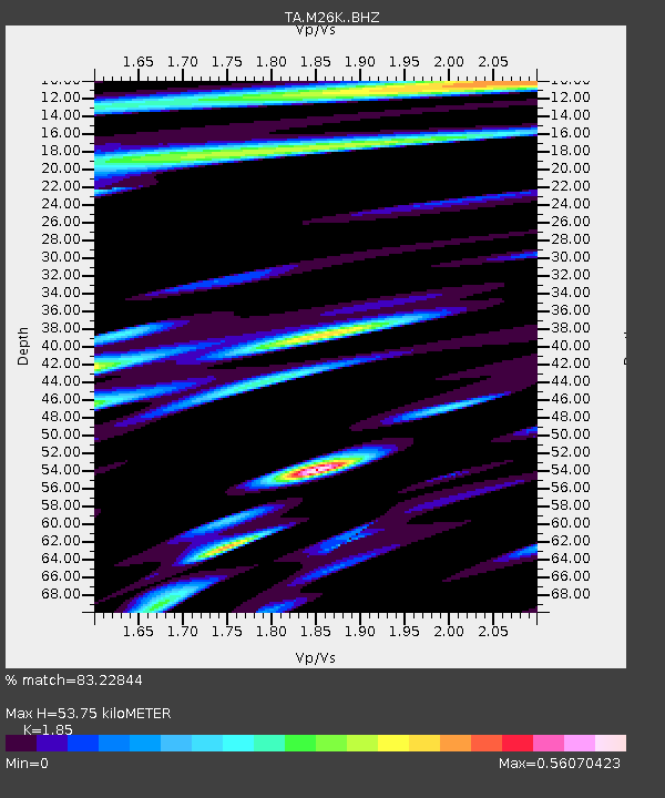
| Estimated Moho Depth: |
53.75 km |
| Estimated Crust Vp/Vs: |
1.85 |
| Assumed Crust Vp: |
6.566 km/s |
| Estimated Crust Vs: |
3.549 km/s |
| Estimated Crust Poisson's Ratio: |
0.29 |
|
| Radial Match: |
83.22844 % |
| Radial Bump: |
400 |
| Transverse Match: |
75.84098 % |
| Transverse Bump: |
400 |
| SOD ConfigId: |
11737051 |
| Insert Time: |
2019-04-25 00:30:50.423 +0000 |
| GWidth: |
2.5 |
| Max Bumps: |
400 |
| Tol: |
0.001 |
|

Signal To Noise
| Channel | StoN | STA | LTA |
| TA:M26K: :BHZ:20160704T09:37:29.625012Z | 3.1396425 | 2.5127457E-7 | 8.003286E-8 |
| TA:M26K: :BHN:20160704T09:37:29.625012Z | 1.8754283 | 1.2622245E-7 | 6.730326E-8 |
| TA:M26K: :BHE:20160704T09:37:29.625012Z | 1.3617121 | 7.0133524E-8 | 5.150393E-8 |
| Arrivals |
| Ps | 7.1 SECOND |
| PpPs | 23 SECOND |
| PsPs/PpSs | 30 SECOND |


