You are here: Home > Network List > AK - Alaska Regional Network Stations List
> Station MDM Murphy Dome > Earthquake Result Viewer
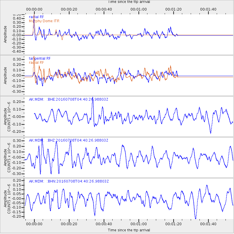
MDM Murphy Dome - Earthquake Result Viewer
*The percent match for this event was below the threshold and hence no stack was calculated.
| Earthquake location: |
Near Coast Of Ecuador |
| Earthquake latitude/longitude: |
-0.4/-80.8 |
| Earthquake time(UTC): |
2016/07/08 (190) 04:28:43 GMT |
| Earthquake Depth: |
7.1 km |
| Earthquake Magnitude: |
5.5 mwb |
| Earthquake Catalog/Contributor: |
NEIC PDE/ |
|
| Network: |
AK Alaska Regional Network |
| Station: |
MDM Murphy Dome |
| Lat/Lon: |
64.96 N/148.23 W |
| Elevation: |
634 m |
|
| Distance: |
81.0 deg |
| Az: |
336.552 deg |
| Baz: |
110.783 deg |
| Ray Param: |
$rayparam |
*The percent match for this event was below the threshold and hence was not used in the summary stack. |
|
| Radial Match: |
54.1506 % |
| Radial Bump: |
400 |
| Transverse Match: |
58.872032 % |
| Transverse Bump: |
400 |
| SOD ConfigId: |
11737051 |
| Insert Time: |
2019-04-25 00:37:27.104 +0000 |
| GWidth: |
2.5 |
| Max Bumps: |
400 |
| Tol: |
0.001 |
|
Signal To Noise
| Channel | StoN | STA | LTA |
| AK:MDM: :BHZ:20160708T04:40:26.98803Z | 3.8222294 | 1.6950553E-7 | 4.4347296E-8 |
| AK:MDM: :BHN:20160708T04:40:26.98803Z | 1.1491657 | 4.766711E-8 | 4.147975E-8 |
| AK:MDM: :BHE:20160708T04:40:26.98803Z | 1.8783845 | 9.87353E-8 | 5.2563944E-8 |
| Arrivals |
| Ps | |
| PpPs | |
| PsPs/PpSs | |


