You are here: Home > Network List > CI - Caltech Regional Seismic Network Stations List
> Station MPP McPhearson Peak > Earthquake Result Viewer
MPP McPhearson Peak - Earthquake Result Viewer
*The percent match for this event was below the threshold and hence no stack was calculated.
| Earthquake location: |
Near Coast Of Ecuador |
| Earthquake latitude/longitude: |
-0.4/-80.8 |
| Earthquake time(UTC): |
2016/07/08 (190) 04:28:43 GMT |
| Earthquake Depth: |
7.1 km |
| Earthquake Magnitude: |
5.5 mwb |
| Earthquake Catalog/Contributor: |
NEIC PDE/ |
|
| Network: |
CI Caltech Regional Seismic Network |
| Station: |
MPP McPhearson Peak |
| Lat/Lon: |
34.89 N/119.81 W |
| Elevation: |
1739 m |
|
| Distance: |
50.6 deg |
| Az: |
317.963 deg |
| Baz: |
125.459 deg |
| Ray Param: |
$rayparam |
*The percent match for this event was below the threshold and hence was not used in the summary stack. |
|
| Radial Match: |
68.38567 % |
| Radial Bump: |
400 |
| Transverse Match: |
62.974876 % |
| Transverse Bump: |
400 |
| SOD ConfigId: |
11737051 |
| Insert Time: |
2019-04-25 00:38:52.215 +0000 |
| GWidth: |
2.5 |
| Max Bumps: |
400 |
| Tol: |
0.001 |
|
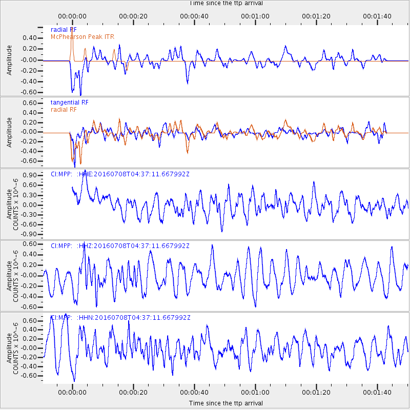
Signal To Noise
| Channel | StoN | STA | LTA |
| CI:MPP: :HHZ:20160708T04:37:11.667992Z | 1.1893677 | 3.8871042E-7 | 3.268211E-7 |
| CI:MPP: :HHN:20160708T04:37:11.667992Z | 0.78123015 | 4.3725964E-7 | 5.5970656E-7 |
| CI:MPP: :HHE:20160708T04:37:11.667992Z | 0.99436766 | 3.1928946E-7 | 3.21098E-7 |
| Arrivals |
| Ps | |
| PpPs | |
| PsPs/PpSs | |


