You are here: Home > Network List > CU - Caribbean Network (USGS) Stations List
> Station GTBY Guantanamo Bay, Cuba > Earthquake Result Viewer
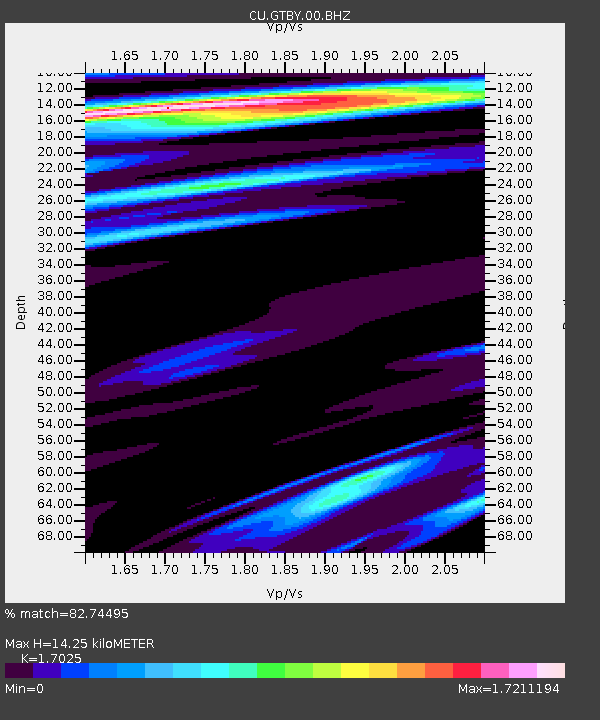
GTBY Guantanamo Bay, Cuba - Earthquake Result Viewer
| Earthquake location: |
Gulf Of California |
| Earthquake latitude/longitude: |
25.2/-109.4 |
| Earthquake time(UTC): |
2015/09/13 (256) 08:14:12 GMT |
| Earthquake Depth: |
10 km |
| Earthquake Magnitude: |
6.6 MWP, 6.8 MI |
| Earthquake Catalog/Contributor: |
NEIC PDE/NEIC COMCAT |
|
| Network: |
CU Caribbean Network (USGS) |
| Station: |
GTBY Guantanamo Bay, Cuba |
| Lat/Lon: |
19.93 N/75.11 W |
| Elevation: |
79 m |
|
| Distance: |
32.0 deg |
| Az: |
92.342 deg |
| Baz: |
285.759 deg |
| Ray Param: |
0.07883036 |
| Estimated Moho Depth: |
14.25 km |
| Estimated Crust Vp/Vs: |
1.70 |
| Assumed Crust Vp: |
6.048 km/s |
| Estimated Crust Vs: |
3.552 km/s |
| Estimated Crust Poisson's Ratio: |
0.24 |
|
| Radial Match: |
82.74495 % |
| Radial Bump: |
373 |
| Transverse Match: |
38.019585 % |
| Transverse Bump: |
387 |
| SOD ConfigId: |
1156111 |
| Insert Time: |
2015-09-27 08:37:07.470 +0000 |
| GWidth: |
2.5 |
| Max Bumps: |
400 |
| Tol: |
0.001 |
|

Signal To Noise
| Channel | StoN | STA | LTA |
| CU:GTBY:00:BHZ:20150913T08:20:08.500009Z | 3.6450207 | 2.0099137E-6 | 5.5141356E-7 |
| CU:GTBY:00:BH1:20150913T08:20:08.500009Z | 3.7276692 | 2.6521109E-6 | 7.114662E-7 |
| CU:GTBY:00:BH2:20150913T08:20:08.500009Z | 0.6949767 | 6.6617497E-7 | 9.585573E-7 |
| Arrivals |
| Ps | 1.8 SECOND |
| PpPs | 5.9 SECOND |
| PsPs/PpSs | 7.7 SECOND |


