You are here: Home > Network List > CI - Caltech Regional Seismic Network Stations List
> Station RRX Rimrock Road, Barstow, CA, USA > Earthquake Result Viewer
RRX Rimrock Road, Barstow, CA, USA - Earthquake Result Viewer
| Earthquake location: |
Fiji Islands Region |
| Earthquake latitude/longitude: |
-17.7/-178.4 |
| Earthquake time(UTC): |
2006/02/02 (033) 12:48:43 GMT |
| Earthquake Depth: |
598 km |
| Earthquake Magnitude: |
5.9 MB, 6.7 MW, 6.7 MW |
| Earthquake Catalog/Contributor: |
WHDF/NEIC |
|
| Network: |
CI Caltech Regional Seismic Network |
| Station: |
RRX Rimrock Road, Barstow, CA, USA |
| Lat/Lon: |
34.88 N/117.00 W |
| Elevation: |
439 m |
|
| Distance: |
78.3 deg |
| Az: |
47.487 deg |
| Baz: |
238.694 deg |
| Ray Param: |
0.047859006 |
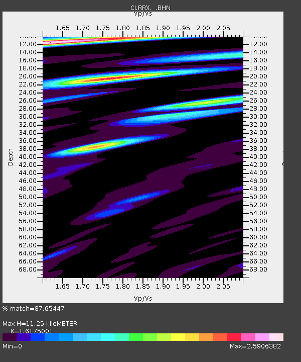
| Estimated Moho Depth: |
11.25 km |
| Estimated Crust Vp/Vs: |
1.62 |
| Assumed Crust Vp: |
6.276 km/s |
| Estimated Crust Vs: |
3.88 km/s |
| Estimated Crust Poisson's Ratio: |
0.19 |
|
| Radial Match: |
87.65447 % |
| Radial Bump: |
400 |
| Transverse Match: |
87.15416 % |
| Transverse Bump: |
400 |
| SOD ConfigId: |
4977 |
| Insert Time: |
2010-02-26 00:32:45.306 +0000 |
| GWidth: |
2.5 |
| Max Bumps: |
400 |
| Tol: |
0.001 |
|
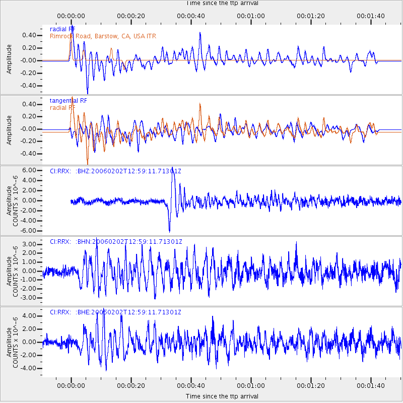
Signal To Noise
| Channel | StoN | STA | LTA |
| CI:RRX: :BHN:20060202T12:59:11.71301Z | 2.7003837 | 9.612031E-7 | 3.5595056E-7 |
| CI:RRX: :BHE:20060202T12:59:11.71301Z | 2.214766 | 1.068441E-6 | 4.824171E-7 |
| CI:RRX: :BHZ:20060202T12:59:11.71301Z | 8.730465 | 3.0400151E-6 | 3.482077E-7 |
| Arrivals |
| Ps | 1.1 SECOND |
| PpPs | 4.6 SECOND |
| PsPs/PpSs | 5.7 SECOND |


