You are here: Home > Network List > IU - Global Seismograph Network (GSN - IRIS/USGS) Stations List
> Station PAYG Puerto Ayora, Galapagos Islands > Earthquake Result Viewer
PAYG Puerto Ayora, Galapagos Islands - Earthquake Result Viewer
| Earthquake location: |
Gulf Of California |
| Earthquake latitude/longitude: |
25.2/-109.4 |
| Earthquake time(UTC): |
2015/09/13 (256) 08:14:12 GMT |
| Earthquake Depth: |
10 km |
| Earthquake Magnitude: |
6.6 MWP, 6.8 MI |
| Earthquake Catalog/Contributor: |
NEIC PDE/NEIC COMCAT |
|
| Network: |
IU Global Seismograph Network (GSN - IRIS/USGS) |
| Station: |
PAYG Puerto Ayora, Galapagos Islands |
| Lat/Lon: |
0.67 S/90.29 W |
| Elevation: |
270 m |
|
| Distance: |
31.6 deg |
| Az: |
141.425 deg |
| Baz: |
325.59 deg |
| Ray Param: |
0.07899321 |
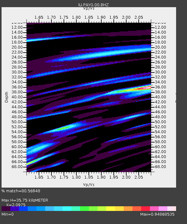
| Estimated Moho Depth: |
35.75 km |
| Estimated Crust Vp/Vs: |
2.10 |
| Assumed Crust Vp: |
4.802 km/s |
| Estimated Crust Vs: |
2.289 km/s |
| Estimated Crust Poisson's Ratio: |
0.35 |
|
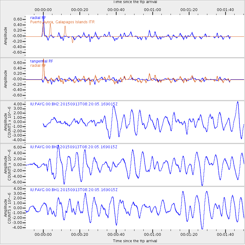
| Radial Match: |
80.56948 % |
| Radial Bump: |
400 |
| Transverse Match: |
70.44254 % |
| Transverse Bump: |
400 |
| SOD ConfigId: |
1156111 |
| Insert Time: |
2015-09-27 08:38:36.806 +0000 |
| GWidth: |
2.5 |
| Max Bumps: |
400 |
| Tol: |
0.001 |
|
Signal To Noise
| Channel | StoN | STA | LTA |
| IU:PAYG:00:BHZ:20150913T08:20:05.169015Z | 2.8352392 | 1.2491749E-6 | 4.4058893E-7 |
| IU:PAYG:00:BH1:20150913T08:20:05.169015Z | 1.7528477 | 7.6782584E-7 | 4.3804482E-7 |
| IU:PAYG:00:BH2:20150913T08:20:05.169015Z | 1.2613347 | 6.284232E-7 | 4.9822086E-7 |
| Arrivals |
| Ps | 8.5 SECOND |
| PpPs | 22 SECOND |
| PsPs/PpSs | 31 SECOND |


