You are here: Home > Network List > TA - USArray Transportable Network (new EarthScope stations) Stations List
> Station 121A Cookes Peak, Deming, NM, USA > Earthquake Result Viewer
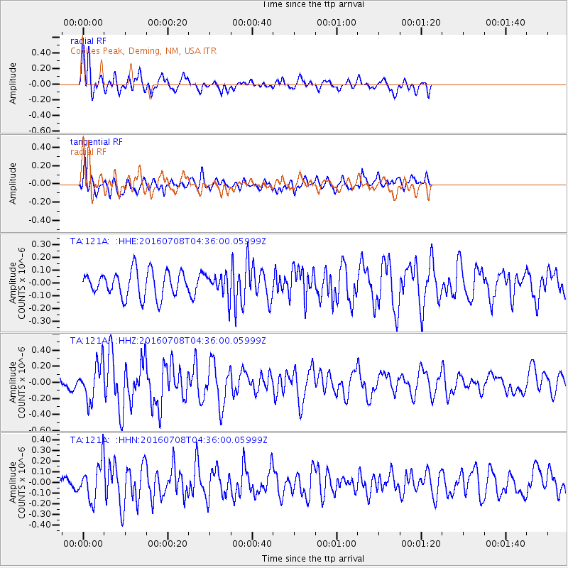
121A Cookes Peak, Deming, NM, USA - Earthquake Result Viewer
*The percent match for this event was below the threshold and hence no stack was calculated.
| Earthquake location: |
Near Coast Of Ecuador |
| Earthquake latitude/longitude: |
-0.4/-80.8 |
| Earthquake time(UTC): |
2016/07/08 (190) 04:28:43 GMT |
| Earthquake Depth: |
7.1 km |
| Earthquake Magnitude: |
5.5 mwb |
| Earthquake Catalog/Contributor: |
NEIC PDE/ |
|
| Network: |
TA USArray Transportable Network (new EarthScope stations) |
| Station: |
121A Cookes Peak, Deming, NM, USA |
| Lat/Lon: |
32.53 N/107.79 W |
| Elevation: |
1652 m |
|
| Distance: |
41.5 deg |
| Az: |
324.665 deg |
| Baz: |
136.791 deg |
| Ray Param: |
$rayparam |
*The percent match for this event was below the threshold and hence was not used in the summary stack. |
|
| Radial Match: |
77.827736 % |
| Radial Bump: |
400 |
| Transverse Match: |
59.12209 % |
| Transverse Bump: |
400 |
| SOD ConfigId: |
11737051 |
| Insert Time: |
2019-04-25 00:43:44.498 +0000 |
| GWidth: |
2.5 |
| Max Bumps: |
400 |
| Tol: |
0.001 |
|
Signal To Noise
| Channel | StoN | STA | LTA |
| TA:121A: :HHZ:20160708T04:36:00.05999Z | 3.0302665 | 2.3457532E-7 | 7.741079E-8 |
| TA:121A: :HHN:20160708T04:36:00.05999Z | 2.6917553 | 1.7427016E-7 | 6.4742196E-8 |
| TA:121A: :HHE:20160708T04:36:00.05999Z | 0.8824549 | 8.755245E-8 | 9.921465E-8 |
| Arrivals |
| Ps | |
| PpPs | |
| PsPs/PpSs | |


