You are here: Home > Network List > TA - USArray Transportable Network (new EarthScope stations) Stations List
> Station I23K Minto, Yukon-Koyukuk, AK, USA > Earthquake Result Viewer
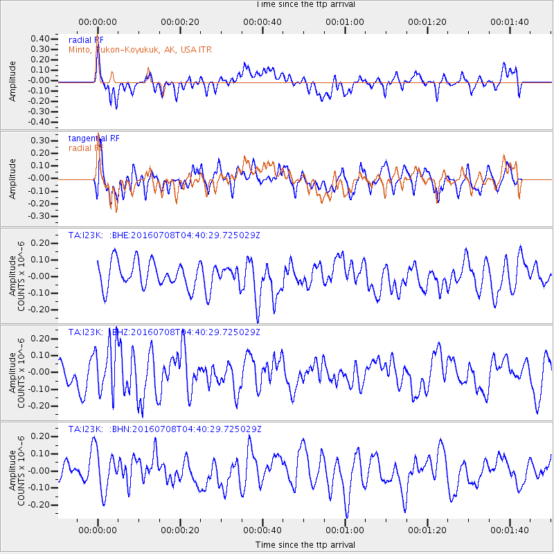
I23K Minto, Yukon-Koyukuk, AK, USA - Earthquake Result Viewer
*The percent match for this event was below the threshold and hence no stack was calculated.
| Earthquake location: |
Near Coast Of Ecuador |
| Earthquake latitude/longitude: |
-0.4/-80.8 |
| Earthquake time(UTC): |
2016/07/08 (190) 04:28:43 GMT |
| Earthquake Depth: |
7.1 km |
| Earthquake Magnitude: |
5.5 mwb |
| Earthquake Catalog/Contributor: |
NEIC PDE/ |
|
| Network: |
TA USArray Transportable Network (new EarthScope stations) |
| Station: |
I23K Minto, Yukon-Koyukuk, AK, USA |
| Lat/Lon: |
65.15 N/149.36 W |
| Elevation: |
149 m |
|
| Distance: |
81.5 deg |
| Az: |
336.564 deg |
| Baz: |
109.761 deg |
| Ray Param: |
$rayparam |
*The percent match for this event was below the threshold and hence was not used in the summary stack. |
|
| Radial Match: |
43.73121 % |
| Radial Bump: |
400 |
| Transverse Match: |
57.0095 % |
| Transverse Bump: |
400 |
| SOD ConfigId: |
11737051 |
| Insert Time: |
2019-04-25 00:43:52.952 +0000 |
| GWidth: |
2.5 |
| Max Bumps: |
400 |
| Tol: |
0.001 |
|
Signal To Noise
| Channel | StoN | STA | LTA |
| TA:I23K: :BHZ:20160708T04:40:29.725029Z | 2.8450494 | 1.4777245E-7 | 5.1940205E-8 |
| TA:I23K: :BHN:20160708T04:40:29.725029Z | 2.341746 | 1.2383025E-7 | 5.2879454E-8 |
| TA:I23K: :BHE:20160708T04:40:29.725029Z | 0.546635 | 4.169876E-8 | 7.628264E-8 |
| Arrivals |
| Ps | |
| PpPs | |
| PsPs/PpSs | |


