You are here: Home > Network List > TA - USArray Transportable Network (new EarthScope stations) Stations List
> Station MSTX Muleshoe, TX, USA > Earthquake Result Viewer
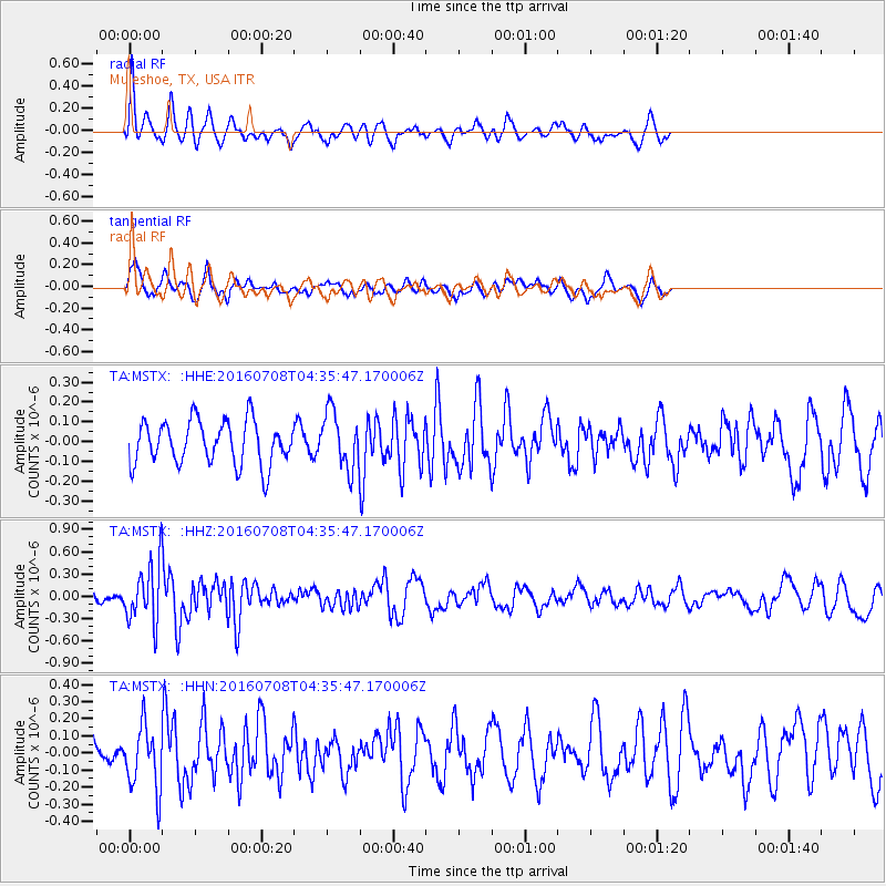
MSTX Muleshoe, TX, USA - Earthquake Result Viewer
*The percent match for this event was below the threshold and hence no stack was calculated.
| Earthquake location: |
Near Coast Of Ecuador |
| Earthquake latitude/longitude: |
-0.4/-80.8 |
| Earthquake time(UTC): |
2016/07/08 (190) 04:28:43 GMT |
| Earthquake Depth: |
7.1 km |
| Earthquake Magnitude: |
5.5 mwb |
| Earthquake Catalog/Contributor: |
NEIC PDE/ |
|
| Network: |
TA USArray Transportable Network (new EarthScope stations) |
| Station: |
MSTX Muleshoe, TX, USA |
| Lat/Lon: |
33.97 N/102.77 W |
| Elevation: |
1167 m |
|
| Distance: |
39.9 deg |
| Az: |
331.035 deg |
| Baz: |
144.359 deg |
| Ray Param: |
$rayparam |
*The percent match for this event was below the threshold and hence was not used in the summary stack. |
|
| Radial Match: |
57.28366 % |
| Radial Bump: |
400 |
| Transverse Match: |
62.93842 % |
| Transverse Bump: |
400 |
| SOD ConfigId: |
11737051 |
| Insert Time: |
2019-04-25 00:44:03.619 +0000 |
| GWidth: |
2.5 |
| Max Bumps: |
400 |
| Tol: |
0.001 |
|
Signal To Noise
| Channel | StoN | STA | LTA |
| TA:MSTX: :HHZ:20160708T04:35:47.170006Z | 3.9280272 | 3.7634163E-7 | 9.580933E-8 |
| TA:MSTX: :HHN:20160708T04:35:47.170006Z | 2.4982183 | 1.8827889E-7 | 7.536527E-8 |
| TA:MSTX: :HHE:20160708T04:35:47.170006Z | 1.292367 | 1.4212667E-7 | 1.0997391E-7 |
| Arrivals |
| Ps | |
| PpPs | |
| PsPs/PpSs | |


