You are here: Home > Network List > TA - USArray Transportable Network (new EarthScope stations) Stations List
> Station SFIN Lafayette, IN, USA > Earthquake Result Viewer
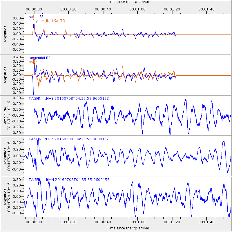
SFIN Lafayette, IN, USA - Earthquake Result Viewer
*The percent match for this event was below the threshold and hence no stack was calculated.
| Earthquake location: |
Near Coast Of Ecuador |
| Earthquake latitude/longitude: |
-0.4/-80.8 |
| Earthquake time(UTC): |
2016/07/08 (190) 04:28:43 GMT |
| Earthquake Depth: |
7.1 km |
| Earthquake Magnitude: |
5.5 mwb |
| Earthquake Catalog/Contributor: |
NEIC PDE/ |
|
| Network: |
TA USArray Transportable Network (new EarthScope stations) |
| Station: |
SFIN Lafayette, IN, USA |
| Lat/Lon: |
40.38 N/87.10 W |
| Elevation: |
165 m |
|
| Distance: |
41.0 deg |
| Az: |
352.671 deg |
| Baz: |
170.387 deg |
| Ray Param: |
$rayparam |
*The percent match for this event was below the threshold and hence was not used in the summary stack. |
|
| Radial Match: |
75.4998 % |
| Radial Bump: |
302 |
| Transverse Match: |
54.89937 % |
| Transverse Bump: |
400 |
| SOD ConfigId: |
11737051 |
| Insert Time: |
2019-04-25 00:44:14.640 +0000 |
| GWidth: |
2.5 |
| Max Bumps: |
400 |
| Tol: |
0.001 |
|
Signal To Noise
| Channel | StoN | STA | LTA |
| TA:SFIN: :HHZ:20160708T04:35:55.960015Z | 2.1472487 | 2.6393948E-7 | 1.2291986E-7 |
| TA:SFIN: :HHN:20160708T04:35:55.960015Z | 1.8546398 | 2.0099752E-7 | 1.083755E-7 |
| TA:SFIN: :HHE:20160708T04:35:55.960015Z | 2.405992 | 1.5258634E-7 | 6.34193E-8 |
| Arrivals |
| Ps | |
| PpPs | |
| PsPs/PpSs | |


