You are here: Home > Network List > US - United States National Seismic Network Stations List
> Station CBKS Cedar Bluff, Kansas, USA > Earthquake Result Viewer
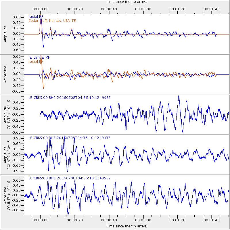
CBKS Cedar Bluff, Kansas, USA - Earthquake Result Viewer
*The percent match for this event was below the threshold and hence no stack was calculated.
| Earthquake location: |
Near Coast Of Ecuador |
| Earthquake latitude/longitude: |
-0.4/-80.8 |
| Earthquake time(UTC): |
2016/07/08 (190) 04:28:43 GMT |
| Earthquake Depth: |
7.1 km |
| Earthquake Magnitude: |
5.5 mwb |
| Earthquake Catalog/Contributor: |
NEIC PDE/ |
|
| Network: |
US United States National Seismic Network |
| Station: |
CBKS Cedar Bluff, Kansas, USA |
| Lat/Lon: |
38.81 N/99.74 W |
| Elevation: |
677 m |
|
| Distance: |
42.7 deg |
| Az: |
338.068 deg |
| Baz: |
151.44 deg |
| Ray Param: |
$rayparam |
*The percent match for this event was below the threshold and hence was not used in the summary stack. |
|
| Radial Match: |
77.71284 % |
| Radial Bump: |
400 |
| Transverse Match: |
64.377304 % |
| Transverse Bump: |
400 |
| SOD ConfigId: |
11737051 |
| Insert Time: |
2019-04-25 00:44:30.754 +0000 |
| GWidth: |
2.5 |
| Max Bumps: |
400 |
| Tol: |
0.001 |
|
Signal To Noise
| Channel | StoN | STA | LTA |
| US:CBKS:00:BHZ:20160708T04:36:10.124993Z | 4.7704973 | 3.2268855E-7 | 6.764254E-8 |
| US:CBKS:00:BH1:20160708T04:36:10.124993Z | 2.845816 | 3.0159669E-7 | 1.0597899E-7 |
| US:CBKS:00:BH2:20160708T04:36:10.124993Z | 1.4508796 | 1.0206448E-7 | 7.034663E-8 |
| Arrivals |
| Ps | |
| PpPs | |
| PsPs/PpSs | |


