You are here: Home > Network List > US - United States National Seismic Network Stations List
> Station HLID Hailey, Idaho, USA > Earthquake Result Viewer
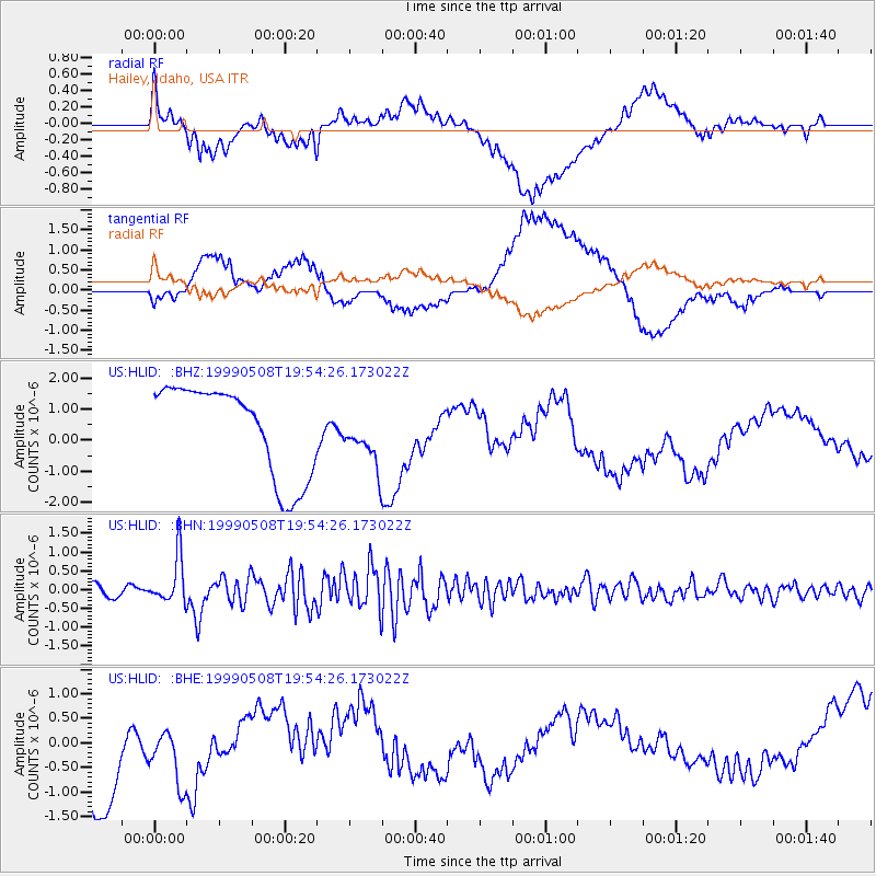
HLID Hailey, Idaho, USA - Earthquake Result Viewer
*The percent match for this event was below the threshold and hence no stack was calculated.
| Earthquake location: |
Kuril Islands |
| Earthquake latitude/longitude: |
45.4/151.6 |
| Earthquake time(UTC): |
1999/05/08 (128) 19:44:35 GMT |
| Earthquake Depth: |
63 km |
| Earthquake Magnitude: |
6.2 MB, 5.3 MS, 5.9 MW, 5.9 MW |
| Earthquake Catalog/Contributor: |
WHDF/NEIC |
|
| Network: |
US United States National Seismic Network |
| Station: |
HLID Hailey, Idaho, USA |
| Lat/Lon: |
43.56 N/114.41 W |
| Elevation: |
1772 m |
|
| Distance: |
63.1 deg |
| Az: |
54.409 deg |
| Baz: |
308.051 deg |
| Ray Param: |
$rayparam |
*The percent match for this event was below the threshold and hence was not used in the summary stack. |
|
| Radial Match: |
56.01373 % |
| Radial Bump: |
400 |
| Transverse Match: |
47.10463 % |
| Transverse Bump: |
400 |
| SOD ConfigId: |
4480 |
| Insert Time: |
2010-03-05 05:06:57.648 +0000 |
| GWidth: |
2.5 |
| Max Bumps: |
400 |
| Tol: |
0.001 |
|
Signal To Noise
| Channel | StoN | STA | LTA |
| US:HLID: :BHN:19990508T19:54:26.173022Z | 5.1514935 | 6.374514E-7 | 1.2374109E-7 |
| US:HLID: :BHE:19990508T19:54:26.173022Z | 0.79741645 | 7.5247243E-7 | 9.4363793E-7 |
| US:HLID: :BHZ:19990508T19:54:26.173022Z | 0.62270135 | 8.998478E-7 | 1.4450712E-6 |
| Arrivals |
| Ps | |
| PpPs | |
| PsPs/PpSs | |


