You are here: Home > Network List > US - United States National Seismic Network Stations List
> Station MSO Missoula, Montana, USA > Earthquake Result Viewer
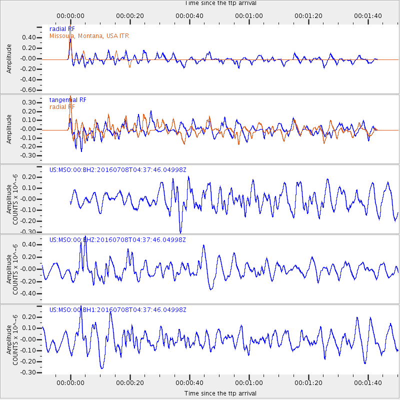
MSO Missoula, Montana, USA - Earthquake Result Viewer
*The percent match for this event was below the threshold and hence no stack was calculated.
| Earthquake location: |
Near Coast Of Ecuador |
| Earthquake latitude/longitude: |
-0.4/-80.8 |
| Earthquake time(UTC): |
2016/07/08 (190) 04:28:43 GMT |
| Earthquake Depth: |
7.1 km |
| Earthquake Magnitude: |
5.5 mwb |
| Earthquake Catalog/Contributor: |
NEIC PDE/ |
|
| Network: |
US United States National Seismic Network |
| Station: |
MSO Missoula, Montana, USA |
| Lat/Lon: |
46.83 N/113.94 W |
| Elevation: |
1264 m |
|
| Distance: |
55.3 deg |
| Az: |
332.826 deg |
| Baz: |
138.308 deg |
| Ray Param: |
$rayparam |
*The percent match for this event was below the threshold and hence was not used in the summary stack. |
|
| Radial Match: |
62.468784 % |
| Radial Bump: |
400 |
| Transverse Match: |
64.06032 % |
| Transverse Bump: |
400 |
| SOD ConfigId: |
11737051 |
| Insert Time: |
2019-04-25 00:44:43.294 +0000 |
| GWidth: |
2.5 |
| Max Bumps: |
400 |
| Tol: |
0.001 |
|
Signal To Noise
| Channel | StoN | STA | LTA |
| US:MSO:00:BHZ:20160708T04:37:46.04998Z | 2.1137848 | 1.9992459E-7 | 9.458133E-8 |
| US:MSO:00:BH1:20160708T04:37:46.04998Z | 2.023204 | 1.1857972E-7 | 5.8609867E-8 |
| US:MSO:00:BH2:20160708T04:37:46.04998Z | 2.122764 | 1.0884294E-7 | 5.127416E-8 |
| Arrivals |
| Ps | |
| PpPs | |
| PsPs/PpSs | |


