You are here: Home > Network List > UW - Pacific Northwest Regional Seismic Network Stations List
> Station UMAT Pilot Rock, OR, USA > Earthquake Result Viewer
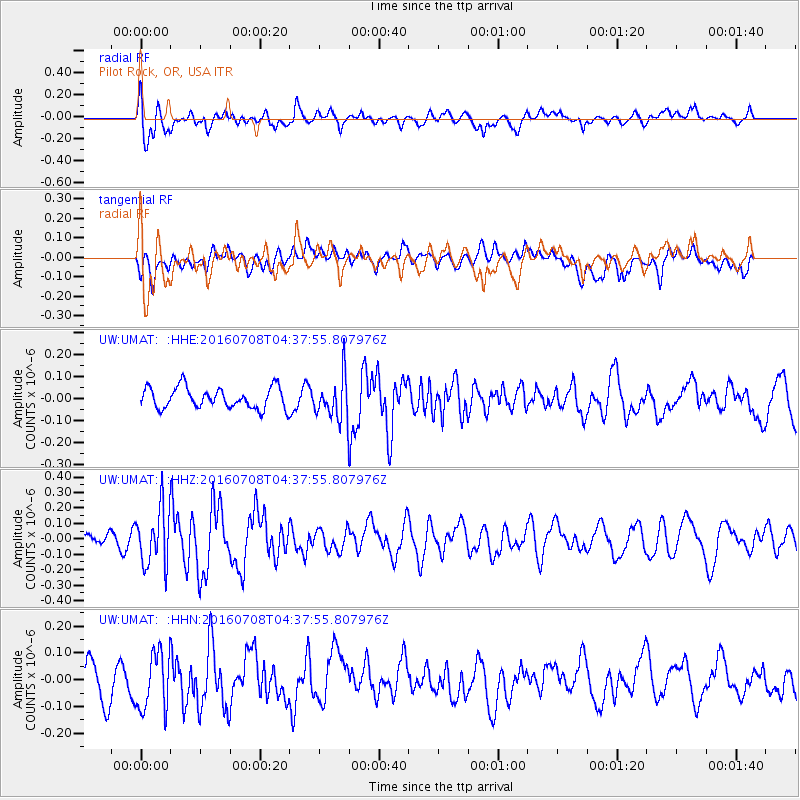
UMAT Pilot Rock, OR, USA - Earthquake Result Viewer
*The percent match for this event was below the threshold and hence no stack was calculated.
| Earthquake location: |
Near Coast Of Ecuador |
| Earthquake latitude/longitude: |
-0.4/-80.8 |
| Earthquake time(UTC): |
2016/07/08 (190) 04:28:43 GMT |
| Earthquake Depth: |
7.1 km |
| Earthquake Magnitude: |
5.5 mwb |
| Earthquake Catalog/Contributor: |
NEIC PDE/ |
|
| Network: |
UW Pacific Northwest Regional Seismic Network |
| Station: |
UMAT Pilot Rock, OR, USA |
| Lat/Lon: |
45.29 N/118.96 W |
| Elevation: |
1318 m |
|
| Distance: |
56.6 deg |
| Az: |
328.522 deg |
| Baz: |
132.294 deg |
| Ray Param: |
$rayparam |
*The percent match for this event was below the threshold and hence was not used in the summary stack. |
|
| Radial Match: |
62.36022 % |
| Radial Bump: |
400 |
| Transverse Match: |
44.65522 % |
| Transverse Bump: |
400 |
| SOD ConfigId: |
11737051 |
| Insert Time: |
2019-04-25 00:45:20.419 +0000 |
| GWidth: |
2.5 |
| Max Bumps: |
400 |
| Tol: |
0.001 |
|
Signal To Noise
| Channel | StoN | STA | LTA |
| UW:UMAT: :HHZ:20160708T04:37:55.807976Z | 3.7858562 | 1.823753E-7 | 4.81728E-8 |
| UW:UMAT: :HHN:20160708T04:37:55.807976Z | 1.740412 | 1.0814348E-7 | 6.213671E-8 |
| UW:UMAT: :HHE:20160708T04:37:55.807976Z | 1.9829912 | 9.410178E-8 | 4.7454463E-8 |
| Arrivals |
| Ps | |
| PpPs | |
| PsPs/PpSs | |


