You are here: Home > Network List > G - GEOSCOPE Stations List
> Station NOUC Port Laguerre, New Caledonia > Earthquake Result Viewer
NOUC Port Laguerre, New Caledonia - Earthquake Result Viewer
| Earthquake location: |
Northern Molucca Sea |
| Earthquake latitude/longitude: |
1.9/126.4 |
| Earthquake time(UTC): |
2015/09/16 (259) 07:40:59 GMT |
| Earthquake Depth: |
53 km |
| Earthquake Magnitude: |
6.3 MWB |
| Earthquake Catalog/Contributor: |
NEIC PDE/NEIC COMCAT |
|
| Network: |
G GEOSCOPE |
| Station: |
NOUC Port Laguerre, New Caledonia |
| Lat/Lon: |
22.10 S/166.30 E |
| Elevation: |
112 m |
|
| Distance: |
45.7 deg |
| Az: |
123.686 deg |
| Baz: |
296.264 deg |
| Ray Param: |
0.07098426 |
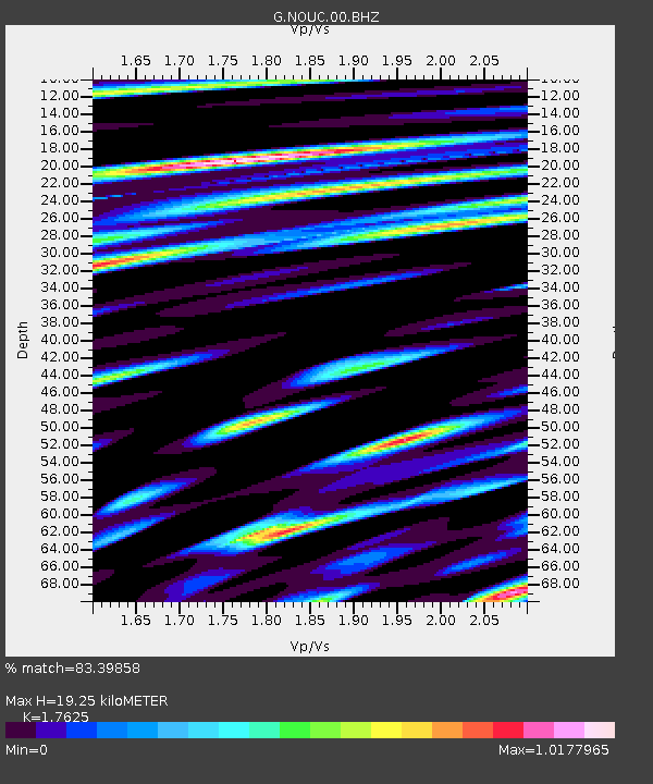
| Estimated Moho Depth: |
19.25 km |
| Estimated Crust Vp/Vs: |
1.76 |
| Assumed Crust Vp: |
5.14 km/s |
| Estimated Crust Vs: |
2.916 km/s |
| Estimated Crust Poisson's Ratio: |
0.26 |
|
| Radial Match: |
83.39858 % |
| Radial Bump: |
400 |
| Transverse Match: |
76.0845 % |
| Transverse Bump: |
400 |
| SOD ConfigId: |
1156111 |
| Insert Time: |
2015-09-30 07:59:39.487 +0000 |
| GWidth: |
2.5 |
| Max Bumps: |
400 |
| Tol: |
0.001 |
|

Signal To Noise
| Channel | StoN | STA | LTA |
| G:NOUC:00:BHZ:20150916T07:48:44.948992Z | 8.502793 | 1.7864551E-6 | 2.1010214E-7 |
| G:NOUC:00:BHN:20150916T07:48:44.948992Z | 1.965906 | 4.5838004E-7 | 2.3316477E-7 |
| G:NOUC:00:BHE:20150916T07:48:44.948992Z | 7.1185074 | 1.117519E-6 | 1.5698782E-7 |
| Arrivals |
| Ps | 3.0 SECOND |
| PpPs | 9.9 SECOND |
| PsPs/PpSs | 13 SECOND |


