You are here: Home > Network List > US - United States National Seismic Network Stations List
> Station HLID Hailey, Idaho, USA > Earthquake Result Viewer
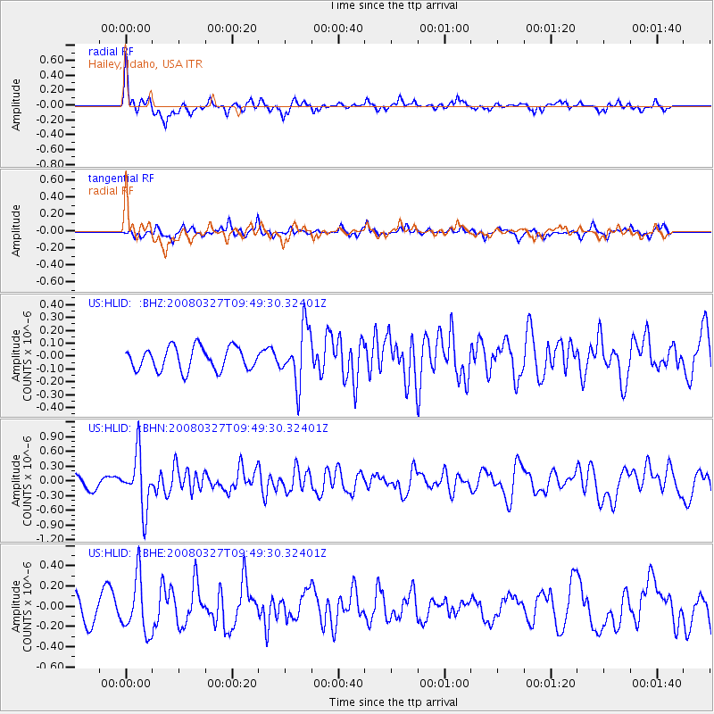
HLID Hailey, Idaho, USA - Earthquake Result Viewer
*The percent match for this event was below the threshold and hence no stack was calculated.
| Earthquake location: |
North Of Honduras |
| Earthquake latitude/longitude: |
17.2/-84.8 |
| Earthquake time(UTC): |
2008/03/27 (087) 09:42:57 GMT |
| Earthquake Depth: |
10 km |
| Earthquake Magnitude: |
5.6 MW, 5.1 MS, 5.4 MB, 5.6 MW |
| Earthquake Catalog/Contributor: |
WHDF/NEIC |
|
| Network: |
US United States National Seismic Network |
| Station: |
HLID Hailey, Idaho, USA |
| Lat/Lon: |
43.56 N/114.41 W |
| Elevation: |
1772 m |
|
| Distance: |
36.3 deg |
| Az: |
322.675 deg |
| Baz: |
127.129 deg |
| Ray Param: |
$rayparam |
*The percent match for this event was below the threshold and hence was not used in the summary stack. |
|
| Radial Match: |
73.44466 % |
| Radial Bump: |
393 |
| Transverse Match: |
58.315643 % |
| Transverse Bump: |
400 |
| SOD ConfigId: |
2504 |
| Insert Time: |
2010-03-05 05:07:25.535 +0000 |
| GWidth: |
2.5 |
| Max Bumps: |
400 |
| Tol: |
0.001 |
|
Signal To Noise
| Channel | StoN | STA | LTA |
| US:HLID: :BHN:20080327T09:49:30.32401Z | 3.5385454 | 5.637208E-7 | 1.5930863E-7 |
| US:HLID: :BHE:20080327T09:49:30.32401Z | 1.9221479 | 2.7510973E-7 | 1.4312621E-7 |
| US:HLID: :BHZ:20080327T09:49:30.32401Z | 2.4770532 | 2.187475E-7 | 8.830957E-8 |
| Arrivals |
| Ps | |
| PpPs | |
| PsPs/PpSs | |


