You are here: Home > Network List > US - United States National Seismic Network Stations List
> Station HLID Hailey, Idaho, USA > Earthquake Result Viewer
HLID Hailey, Idaho, USA - Earthquake Result Viewer
*The percent match for this event was below the threshold and hence no stack was calculated.
| Earthquake location: |
Near East Coast Of Honshu, Japan |
| Earthquake latitude/longitude: |
36.2/141.5 |
| Earthquake time(UTC): |
2008/05/07 (128) 16:45:20 GMT |
| Earthquake Depth: |
39 km |
| Earthquake Magnitude: |
6.1 MB, 6.7 MS, 6.8 MW, 6.8 MW |
| Earthquake Catalog/Contributor: |
WHDF/NEIC |
|
| Network: |
US United States National Seismic Network |
| Station: |
HLID Hailey, Idaho, USA |
| Lat/Lon: |
43.56 N/114.41 W |
| Elevation: |
1772 m |
|
| Distance: |
74.9 deg |
| Az: |
46.915 deg |
| Baz: |
305.603 deg |
| Ray Param: |
$rayparam |
*The percent match for this event was below the threshold and hence was not used in the summary stack. |
|
| Radial Match: |
54.325184 % |
| Radial Bump: |
397 |
| Transverse Match: |
61.999504 % |
| Transverse Bump: |
400 |
| SOD ConfigId: |
2504 |
| Insert Time: |
2010-03-05 05:07:29.084 +0000 |
| GWidth: |
2.5 |
| Max Bumps: |
400 |
| Tol: |
0.001 |
|
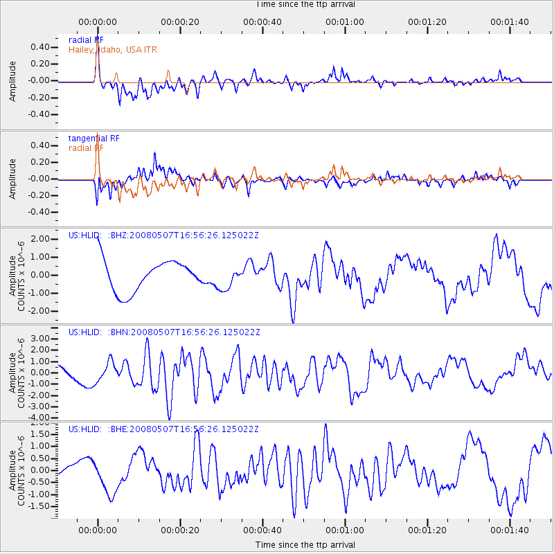
Signal To Noise
| Channel | StoN | STA | LTA |
| US:HLID: :BHN:20080507T16:56:26.125022Z | 1.5657921 | 8.6055087E-7 | 5.4959463E-7 |
| US:HLID: :BHE:20080507T16:56:26.125022Z | 3.039771 | 7.156984E-7 | 2.3544483E-7 |
| US:HLID: :BHZ:20080507T16:56:26.125022Z | 0.74035704 | 6.3496674E-7 | 8.5764935E-7 |
| Arrivals |
| Ps | |
| PpPs | |
| PsPs/PpSs | |


