You are here: Home > Network List > CI - Caltech Regional Seismic Network Stations List
> Station RRX Rimrock Road, Barstow, CA, USA > Earthquake Result Viewer
RRX Rimrock Road, Barstow, CA, USA - Earthquake Result Viewer
| Earthquake location: |
Caribbean Sea |
| Earthquake latitude/longitude: |
17.8/-81.6 |
| Earthquake time(UTC): |
2004/09/09 (253) 16:33:21 GMT |
| Earthquake Depth: |
25 km |
| Earthquake Magnitude: |
5.8 MB, 5.4 MS, 6.0 MW, 6.0 MW |
| Earthquake Catalog/Contributor: |
WHDF/NEIC |
|
| Network: |
CI Caltech Regional Seismic Network |
| Station: |
RRX Rimrock Road, Barstow, CA, USA |
| Lat/Lon: |
34.88 N/117.00 W |
| Elevation: |
439 m |
|
| Distance: |
35.8 deg |
| Az: |
305.44 deg |
| Baz: |
109.216 deg |
| Ray Param: |
0.076977 |
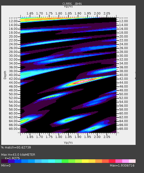
| Estimated Moho Depth: |
43.0 km |
| Estimated Crust Vp/Vs: |
1.93 |
| Assumed Crust Vp: |
6.276 km/s |
| Estimated Crust Vs: |
3.256 km/s |
| Estimated Crust Poisson's Ratio: |
0.32 |
|
| Radial Match: |
80.62739 % |
| Radial Bump: |
346 |
| Transverse Match: |
74.14956 % |
| Transverse Bump: |
400 |
| SOD ConfigId: |
2459 |
| Insert Time: |
2010-02-26 00:32:57.295 +0000 |
| GWidth: |
2.5 |
| Max Bumps: |
400 |
| Tol: |
0.001 |
|

Signal To Noise
| Channel | StoN | STA | LTA |
| CI:RRX: :BHN:20040909T16:39:48.465006Z | 1.0674982 | 2.7058906E-7 | 2.534796E-7 |
| CI:RRX: :BHE:20040909T16:39:48.465006Z | 2.2864516 | 9.410596E-7 | 4.115808E-7 |
| CI:RRX: :BHZ:20040909T16:39:48.465006Z | 6.1791506 | 1.3478208E-6 | 2.1812396E-7 |
| Arrivals |
| Ps | 6.8 SECOND |
| PpPs | 19 SECOND |
| PsPs/PpSs | 26 SECOND |


