You are here: Home > Network List > US - United States National Seismic Network Stations List
> Station HLID Hailey, Idaho, USA > Earthquake Result Viewer
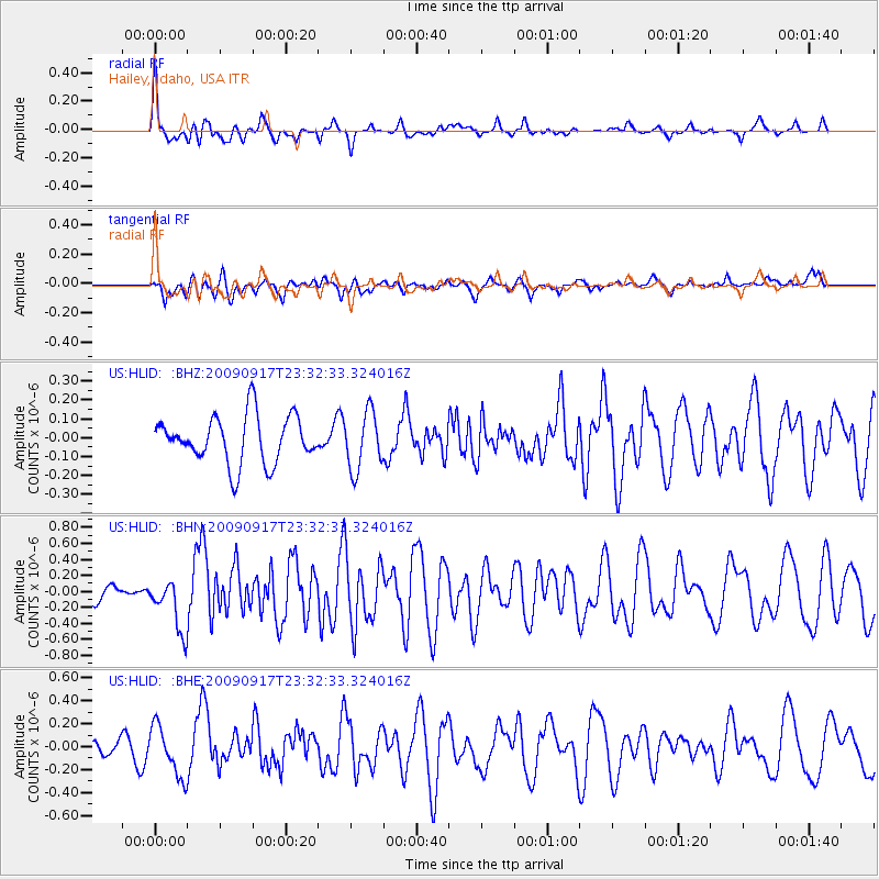
HLID Hailey, Idaho, USA - Earthquake Result Viewer
*The percent match for this event was below the threshold and hence no stack was calculated.
| Earthquake location: |
Easter Island Region |
| Earthquake latitude/longitude: |
-29.1/-112.3 |
| Earthquake time(UTC): |
2009/09/17 (260) 23:21:38 GMT |
| Earthquake Depth: |
10 km |
| Earthquake Magnitude: |
5.7 MB, 6.0 MS, 6.2 MW, 6.2 MW |
| Earthquake Catalog/Contributor: |
WHDF/NEIC |
|
| Network: |
US United States National Seismic Network |
| Station: |
HLID Hailey, Idaho, USA |
| Lat/Lon: |
43.56 N/114.41 W |
| Elevation: |
1772 m |
|
| Distance: |
72.4 deg |
| Az: |
358.363 deg |
| Baz: |
178.03 deg |
| Ray Param: |
$rayparam |
*The percent match for this event was below the threshold and hence was not used in the summary stack. |
|
| Radial Match: |
75.91228 % |
| Radial Bump: |
386 |
| Transverse Match: |
48.208694 % |
| Transverse Bump: |
400 |
| SOD ConfigId: |
2622 |
| Insert Time: |
2010-03-05 05:08:09.155 +0000 |
| GWidth: |
2.5 |
| Max Bumps: |
400 |
| Tol: |
0.001 |
|
Signal To Noise
| Channel | StoN | STA | LTA |
| US:HLID: :BHN:20090917T23:32:33.324016Z | 4.2374673 | 3.2612743E-7 | 7.696283E-8 |
| US:HLID: :BHE:20090917T23:32:33.324016Z | 3.0713258 | 2.1856093E-7 | 7.116175E-8 |
| US:HLID: :BHZ:20090917T23:32:33.324016Z | 1.2154619 | 1.5217964E-7 | 1.2520314E-7 |
| Arrivals |
| Ps | |
| PpPs | |
| PsPs/PpSs | |


