You are here: Home > Network List > TA - USArray Transportable Network (new EarthScope stations) Stations List
> Station G22K Bettles, AK, USA > Earthquake Result Viewer
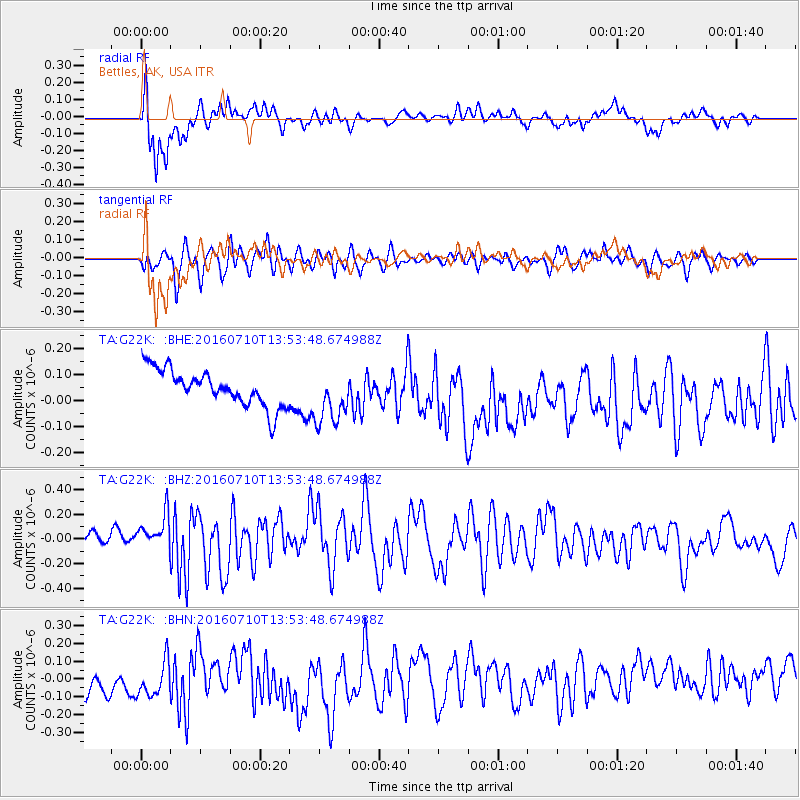
G22K Bettles, AK, USA - Earthquake Result Viewer
*The percent match for this event was below the threshold and hence no stack was calculated.
| Earthquake location: |
Samoa Islands Region |
| Earthquake latitude/longitude: |
-15.0/-172.9 |
| Earthquake time(UTC): |
2016/07/10 (192) 13:41:53 GMT |
| Earthquake Depth: |
10 km |
| Earthquake Magnitude: |
5.5 MB |
| Earthquake Catalog/Contributor: |
NEIC PDE/NEIC ALERT |
|
| Network: |
TA USArray Transportable Network (new EarthScope stations) |
| Station: |
G22K Bettles, AK, USA |
| Lat/Lon: |
66.92 N/151.51 W |
| Elevation: |
205 m |
|
| Distance: |
83.2 deg |
| Az: |
8.317 deg |
| Baz: |
200.763 deg |
| Ray Param: |
$rayparam |
*The percent match for this event was below the threshold and hence was not used in the summary stack. |
|
| Radial Match: |
63.39383 % |
| Radial Bump: |
400 |
| Transverse Match: |
71.415855 % |
| Transverse Bump: |
400 |
| SOD ConfigId: |
11737051 |
| Insert Time: |
2019-04-25 00:59:36.140 +0000 |
| GWidth: |
2.5 |
| Max Bumps: |
400 |
| Tol: |
0.001 |
|
Signal To Noise
| Channel | StoN | STA | LTA |
| TA:G22K: :BHZ:20160710T13:53:48.674988Z | 1.9601218 | 1.9496129E-7 | 9.946386E-8 |
| TA:G22K: :BHN:20160710T13:53:48.674988Z | 1.0259835 | 1.4108117E-7 | 1.3750824E-7 |
| TA:G22K: :BHE:20160710T13:53:48.674988Z | 1.5576104 | 1.08934E-7 | 6.993662E-8 |
| Arrivals |
| Ps | |
| PpPs | |
| PsPs/PpSs | |


