You are here: Home > Network List > US - United States National Seismic Network Stations List
> Station HLID Hailey, Idaho, USA > Earthquake Result Viewer
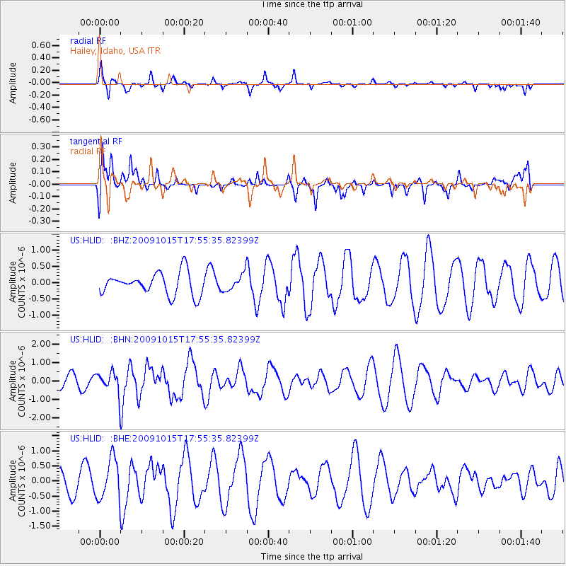
HLID Hailey, Idaho, USA - Earthquake Result Viewer
*The percent match for this event was below the threshold and hence no stack was calculated.
| Earthquake location: |
Galapagos Triple Junction Region |
| Earthquake latitude/longitude: |
3.3/-103.8 |
| Earthquake time(UTC): |
2009/10/15 (288) 17:48:21 GMT |
| Earthquake Depth: |
10 km |
| Earthquake Magnitude: |
5.9 MB, 5.7 MS, 6.0 MW, 6.0 MW |
| Earthquake Catalog/Contributor: |
WHDF/NEIC |
|
| Network: |
US United States National Seismic Network |
| Station: |
HLID Hailey, Idaho, USA |
| Lat/Lon: |
43.56 N/114.41 W |
| Elevation: |
1772 m |
|
| Distance: |
41.2 deg |
| Az: |
348.299 deg |
| Baz: |
163.827 deg |
| Ray Param: |
$rayparam |
*The percent match for this event was below the threshold and hence was not used in the summary stack. |
|
| Radial Match: |
54.795673 % |
| Radial Bump: |
263 |
| Transverse Match: |
48.735504 % |
| Transverse Bump: |
392 |
| SOD ConfigId: |
2622 |
| Insert Time: |
2010-03-05 05:08:14.787 +0000 |
| GWidth: |
2.5 |
| Max Bumps: |
400 |
| Tol: |
0.001 |
|
Signal To Noise
| Channel | StoN | STA | LTA |
| US:HLID: :BHN:20091015T17:55:35.82399Z | 1.9736247 | 6.096417E-7 | 3.0889444E-7 |
| US:HLID: :BHE:20091015T17:55:35.82399Z | 2.4558113 | 6.9703896E-7 | 2.8383246E-7 |
| US:HLID: :BHZ:20091015T17:55:35.82399Z | 0.7926482 | 2.7321184E-7 | 3.4468235E-7 |
| Arrivals |
| Ps | |
| PpPs | |
| PsPs/PpSs | |


