You are here: Home > Network List > CI - Caltech Regional Seismic Network Stations List
> Station RRX Rimrock Road, Barstow, CA, USA > Earthquake Result Viewer
RRX Rimrock Road, Barstow, CA, USA - Earthquake Result Viewer
| Earthquake location: |
Caribbean Sea |
| Earthquake latitude/longitude: |
19.0/-81.4 |
| Earthquake time(UTC): |
2004/12/14 (349) 23:20:13 GMT |
| Earthquake Depth: |
10 km |
| Earthquake Magnitude: |
6.2 MB, 6.7 MS, 6.8 MW, 6.8 MW |
| Earthquake Catalog/Contributor: |
WHDF/NEIC |
|
| Network: |
CI Caltech Regional Seismic Network |
| Station: |
RRX Rimrock Road, Barstow, CA, USA |
| Lat/Lon: |
34.88 N/117.00 W |
| Elevation: |
439 m |
|
| Distance: |
35.3 deg |
| Az: |
304.005 deg |
| Baz: |
107.398 deg |
| Ray Param: |
0.07732064 |
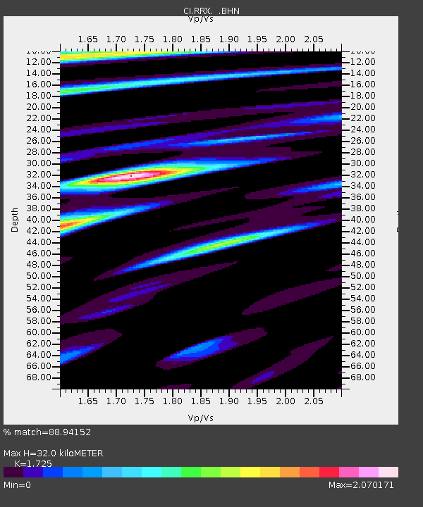
| Estimated Moho Depth: |
32.0 km |
| Estimated Crust Vp/Vs: |
1.73 |
| Assumed Crust Vp: |
6.276 km/s |
| Estimated Crust Vs: |
3.638 km/s |
| Estimated Crust Poisson's Ratio: |
0.25 |
|
| Radial Match: |
88.94152 % |
| Radial Bump: |
400 |
| Transverse Match: |
79.06379 % |
| Transverse Bump: |
400 |
| SOD ConfigId: |
2459 |
| Insert Time: |
2010-02-26 00:32:58.705 +0000 |
| GWidth: |
2.5 |
| Max Bumps: |
400 |
| Tol: |
0.001 |
|
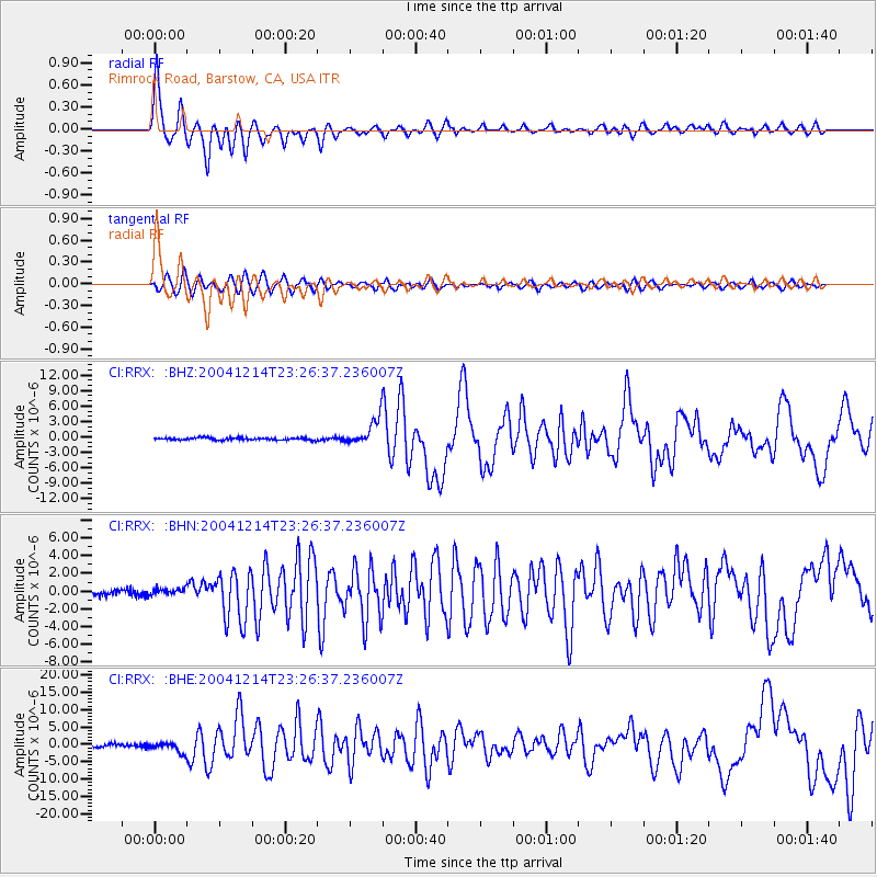
Signal To Noise
| Channel | StoN | STA | LTA |
| CI:RRX: :BHN:20041214T23:26:37.236007Z | 0.82608795 | 3.9078571E-7 | 4.7305582E-7 |
| CI:RRX: :BHE:20041214T23:26:37.236007Z | 4.378831 | 1.4033533E-6 | 3.2048584E-7 |
| CI:RRX: :BHZ:20041214T23:26:37.236007Z | 11.812297 | 2.559985E-6 | 2.1672203E-7 |
| Arrivals |
| Ps | 4.0 SECOND |
| PpPs | 13 SECOND |
| PsPs/PpSs | 17 SECOND |


