You are here: Home > Network List > US - United States National Seismic Network Stations List
> Station HLID Hailey, Idaho, USA > Earthquake Result Viewer
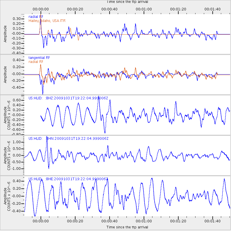
HLID Hailey, Idaho, USA - Earthquake Result Viewer
*The percent match for this event was below the threshold and hence no stack was calculated.
| Earthquake location: |
Santa Cruz Islands |
| Earthquake latitude/longitude: |
-11.4/166.4 |
| Earthquake time(UTC): |
2009/10/31 (304) 19:09:51 GMT |
| Earthquake Depth: |
134 km |
| Earthquake Magnitude: |
5.9 MB, 5.9 MW, 5.9 MW |
| Earthquake Catalog/Contributor: |
WHDF/NEIC |
|
| Network: |
US United States National Seismic Network |
| Station: |
HLID Hailey, Idaho, USA |
| Lat/Lon: |
43.56 N/114.41 W |
| Elevation: |
1772 m |
|
| Distance: |
90.1 deg |
| Az: |
45.568 deg |
| Baz: |
254.423 deg |
| Ray Param: |
$rayparam |
*The percent match for this event was below the threshold and hence was not used in the summary stack. |
|
| Radial Match: |
47.65891 % |
| Radial Bump: |
400 |
| Transverse Match: |
65.61206 % |
| Transverse Bump: |
357 |
| SOD ConfigId: |
2622 |
| Insert Time: |
2010-03-05 05:08:17.106 +0000 |
| GWidth: |
2.5 |
| Max Bumps: |
400 |
| Tol: |
0.001 |
|
Signal To Noise
| Channel | StoN | STA | LTA |
| US:HLID: :BHN:20091031T19:22:04.999006Z | 3.4446983 | 5.684592E-7 | 1.6502437E-7 |
| US:HLID: :BHE:20091031T19:22:04.999006Z | 1.0841349 | 3.1979022E-7 | 2.9497272E-7 |
| US:HLID: :BHZ:20091031T19:22:04.999006Z | 1.1838572 | 3.3853226E-7 | 2.85957E-7 |
| Arrivals |
| Ps | |
| PpPs | |
| PsPs/PpSs | |


