You are here: Home > Network List > US - United States National Seismic Network Stations List
> Station HLID Hailey, Idaho, USA > Earthquake Result Viewer
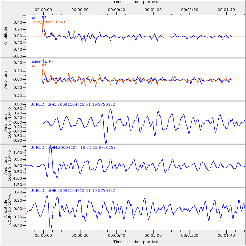
HLID Hailey, Idaho, USA - Earthquake Result Viewer
*The percent match for this event was below the threshold and hence no stack was calculated.
| Earthquake location: |
Azores Islands Region |
| Earthquake latitude/longitude: |
36.2/-33.9 |
| Earthquake time(UTC): |
2009/11/04 (308) 18:41:44 GMT |
| Earthquake Depth: |
10 km |
| Earthquake Magnitude: |
5.7 MB, 5.6 MS, 5.9 MW, 5.8 MW |
| Earthquake Catalog/Contributor: |
WHDF/NEIC |
|
| Network: |
US United States National Seismic Network |
| Station: |
HLID Hailey, Idaho, USA |
| Lat/Lon: |
43.56 N/114.41 W |
| Elevation: |
1772 m |
|
| Distance: |
60.0 deg |
| Az: |
304.106 deg |
| Baz: |
67.197 deg |
| Ray Param: |
$rayparam |
*The percent match for this event was below the threshold and hence was not used in the summary stack. |
|
| Radial Match: |
73.14258 % |
| Radial Bump: |
249 |
| Transverse Match: |
48.86555 % |
| Transverse Bump: |
366 |
| SOD ConfigId: |
2622 |
| Insert Time: |
2010-03-05 05:08:21.858 +0000 |
| GWidth: |
2.5 |
| Max Bumps: |
400 |
| Tol: |
0.001 |
|
Signal To Noise
| Channel | StoN | STA | LTA |
| US:HLID: :BHN:20091104T18:51:19.875015Z | 4.7395935 | 7.970314E-7 | 1.6816452E-7 |
| US:HLID: :BHE:20091104T18:51:19.875015Z | 2.5197651 | 2.7400657E-7 | 1.08742896E-7 |
| US:HLID: :BHZ:20091104T18:51:19.875015Z | 2.9901214 | 4.3792107E-7 | 1.4645595E-7 |
| Arrivals |
| Ps | |
| PpPs | |
| PsPs/PpSs | |


