You are here: Home > Network List > AK - Alaska Regional Network Stations List
> Station MDM Murphy Dome > Earthquake Result Viewer
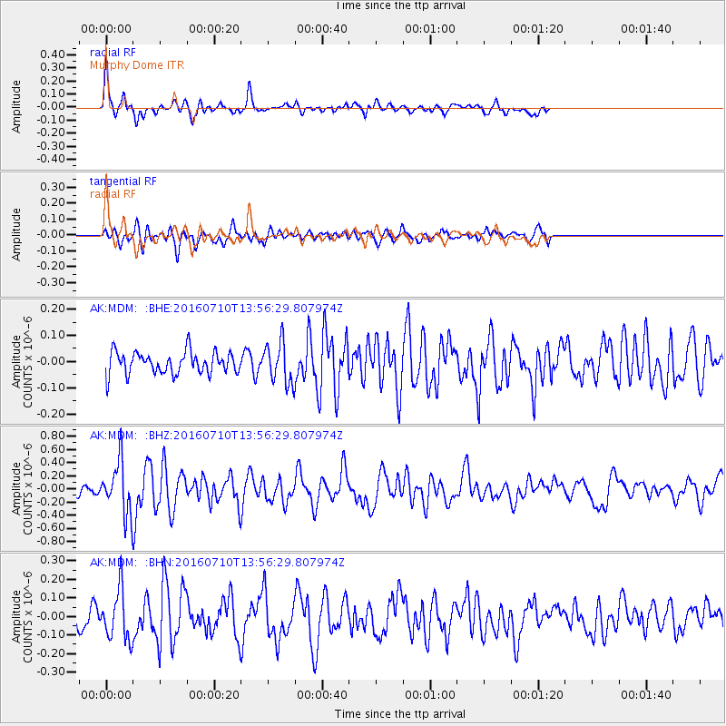
MDM Murphy Dome - Earthquake Result Viewer
*The percent match for this event was below the threshold and hence no stack was calculated.
| Earthquake location: |
Tonga Islands |
| Earthquake latitude/longitude: |
-15.1/-173.2 |
| Earthquake time(UTC): |
2016/07/10 (192) 13:44:41 GMT |
| Earthquake Depth: |
10 km |
| Earthquake Magnitude: |
5.5 MB, 5.8 MWB |
| Earthquake Catalog/Contributor: |
NEIC PDE/NEIC COMCAT |
|
| Network: |
AK Alaska Regional Network |
| Station: |
MDM Murphy Dome |
| Lat/Lon: |
64.96 N/148.23 W |
| Elevation: |
634 m |
|
| Distance: |
82.0 deg |
| Az: |
10.459 deg |
| Baz: |
204.332 deg |
| Ray Param: |
$rayparam |
*The percent match for this event was below the threshold and hence was not used in the summary stack. |
|
| Radial Match: |
77.982216 % |
| Radial Bump: |
349 |
| Transverse Match: |
75.98088 % |
| Transverse Bump: |
400 |
| SOD ConfigId: |
11737051 |
| Insert Time: |
2019-04-25 01:03:14.094 +0000 |
| GWidth: |
2.5 |
| Max Bumps: |
400 |
| Tol: |
0.001 |
|
Signal To Noise
| Channel | StoN | STA | LTA |
| AK:MDM: :BHZ:20160710T13:56:29.807974Z | 3.8418837 | 3.9760565E-7 | 1.03492376E-7 |
| AK:MDM: :BHN:20160710T13:56:29.807974Z | 1.9378806 | 1.373862E-7 | 7.089508E-8 |
| AK:MDM: :BHE:20160710T13:56:29.807974Z | 1.8033934 | 7.621688E-8 | 4.2263032E-8 |
| Arrivals |
| Ps | |
| PpPs | |
| PsPs/PpSs | |


