You are here: Home > Network List > US - United States National Seismic Network Stations List
> Station HAWA Hanford, Washington, USA > Earthquake Result Viewer
HAWA Hanford, Washington, USA - Earthquake Result Viewer
| Earthquake location: |
Near West Coast Of Colombia |
| Earthquake latitude/longitude: |
3.0/-78.0 |
| Earthquake time(UTC): |
2007/09/10 (253) 01:49:14 GMT |
| Earthquake Depth: |
31 km |
| Earthquake Magnitude: |
6.1 MB, 6.7 MS, 6.8 MW |
| Earthquake Catalog/Contributor: |
WHDF/NEIC |
|
| Network: |
US United States National Seismic Network |
| Station: |
HAWA Hanford, Washington, USA |
| Lat/Lon: |
46.39 N/119.53 W |
| Elevation: |
364 m |
|
| Distance: |
56.3 deg |
| Az: |
326.509 deg |
| Baz: |
127.233 deg |
| Ray Param: |
0.064161256 |
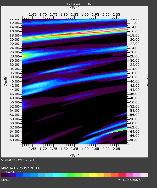
| Estimated Moho Depth: |
15.25 km |
| Estimated Crust Vp/Vs: |
2.02 |
| Assumed Crust Vp: |
6.419 km/s |
| Estimated Crust Vs: |
3.182 km/s |
| Estimated Crust Poisson's Ratio: |
0.34 |
|
| Radial Match: |
92.37098 % |
| Radial Bump: |
364 |
| Transverse Match: |
83.19026 % |
| Transverse Bump: |
400 |
| SOD ConfigId: |
2564 |
| Insert Time: |
2010-03-05 05:09:35.560 +0000 |
| GWidth: |
2.5 |
| Max Bumps: |
400 |
| Tol: |
0.001 |
|
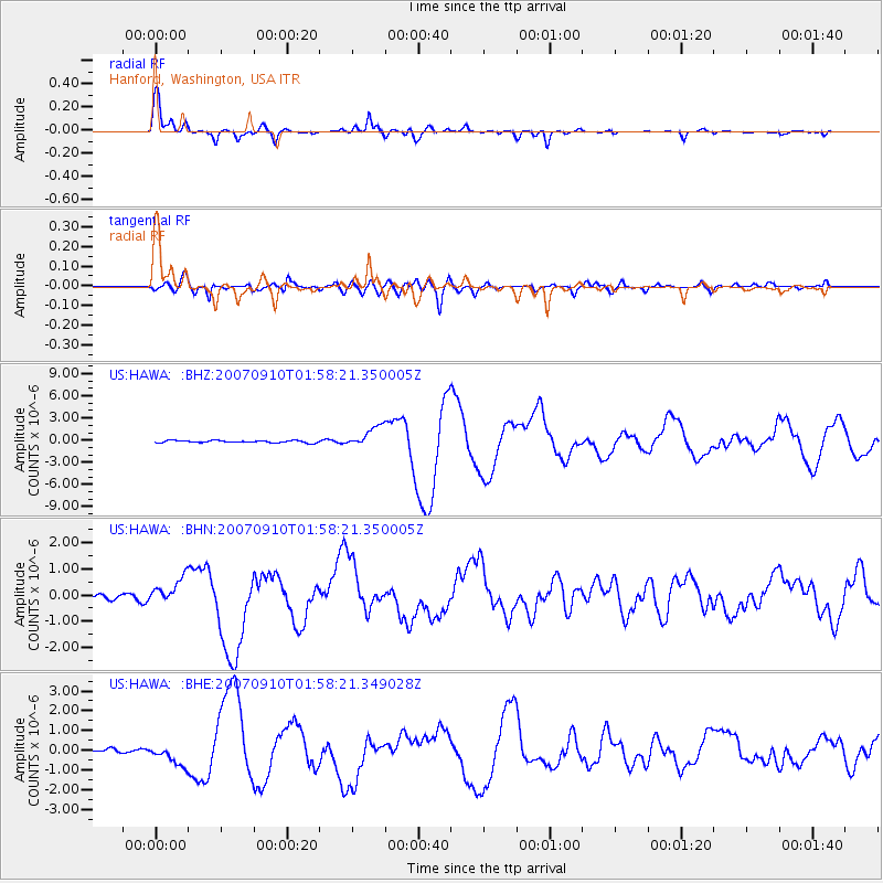
Signal To Noise
| Channel | StoN | STA | LTA |
| US:HAWA: :BHN:20070910T01:58:21.350005Z | 5.805314 | 4.8275757E-7 | 8.315787E-8 |
| US:HAWA: :BHE:20070910T01:58:21.349028Z | 3.7061713 | 5.120049E-7 | 1.3814929E-7 |
| US:HAWA: :BHZ:20070910T01:58:21.350005Z | 9.628007 | 1.4137037E-6 | 1.4683243E-7 |
| Arrivals |
| Ps | 2.5 SECOND |
| PpPs | 6.9 SECOND |
| PsPs/PpSs | 9.4 SECOND |


