You are here: Home > Network List > CI - Caltech Regional Seismic Network Stations List
> Station RRX Rimrock Road, Barstow, CA, USA > Earthquake Result Viewer
RRX Rimrock Road, Barstow, CA, USA - Earthquake Result Viewer
| Earthquake location: |
Kuril Islands |
| Earthquake latitude/longitude: |
47.2/151.3 |
| Earthquake time(UTC): |
2004/07/08 (190) 10:30:49 GMT |
| Earthquake Depth: |
128 km |
| Earthquake Magnitude: |
5.9 MB, 6.4 MW, 6.3 MW |
| Earthquake Catalog/Contributor: |
WHDF/NEIC |
|
| Network: |
CI Caltech Regional Seismic Network |
| Station: |
RRX Rimrock Road, Barstow, CA, USA |
| Lat/Lon: |
34.88 N/117.00 W |
| Elevation: |
439 m |
|
| Distance: |
66.4 deg |
| Az: |
63.71 deg |
| Baz: |
311.961 deg |
| Ray Param: |
0.057258096 |
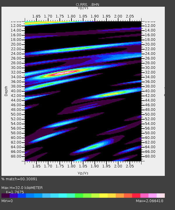
| Estimated Moho Depth: |
32.0 km |
| Estimated Crust Vp/Vs: |
1.77 |
| Assumed Crust Vp: |
6.276 km/s |
| Estimated Crust Vs: |
3.551 km/s |
| Estimated Crust Poisson's Ratio: |
0.26 |
|
| Radial Match: |
80.30891 % |
| Radial Bump: |
400 |
| Transverse Match: |
77.50445 % |
| Transverse Bump: |
400 |
| SOD ConfigId: |
2459 |
| Insert Time: |
2010-02-26 00:33:14.959 +0000 |
| GWidth: |
2.5 |
| Max Bumps: |
400 |
| Tol: |
0.001 |
|
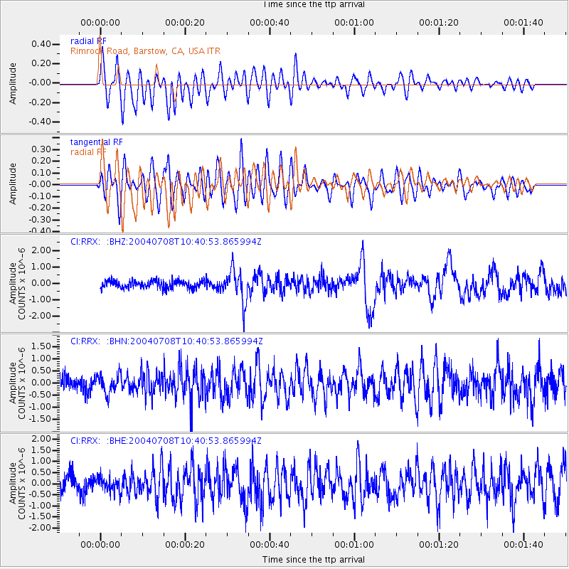
Signal To Noise
| Channel | StoN | STA | LTA |
| CI:RRX: :BHN:20040708T10:40:53.865994Z | 1.5269057 | 3.9540234E-7 | 2.5895662E-7 |
| CI:RRX: :BHE:20040708T10:40:53.865994Z | 0.83674973 | 3.293593E-7 | 3.9361743E-7 |
| CI:RRX: :BHZ:20040708T10:40:53.865994Z | 4.225051 | 9.923151E-7 | 2.3486464E-7 |
| Arrivals |
| Ps | 4.1 SECOND |
| PpPs | 14 SECOND |
| PsPs/PpSs | 18 SECOND |


