You are here: Home > Network List > 7A - Mid-Atlantic Geophysical Integrative Collaboration Stations List
> Station WTMN Standardsville, Virginia USA > Earthquake Result Viewer
WTMN Standardsville, Virginia USA - Earthquake Result Viewer
| Earthquake location: |
Near Coast Of Ecuador |
| Earthquake latitude/longitude: |
0.6/-79.6 |
| Earthquake time(UTC): |
2016/07/11 (193) 02:01:09 GMT |
| Earthquake Depth: |
14 km |
| Earthquake Magnitude: |
5.8 MWW, 5.7 MWB, 5.9 MWC |
| Earthquake Catalog/Contributor: |
NEIC PDE/NEIC COMCAT |
|
| Network: |
7A Mid-Atlantic Geophysical Integrative Collaboration |
| Station: |
WTMN Standardsville, Virginia USA |
| Lat/Lon: |
38.30 N/78.48 W |
| Elevation: |
178 m |
|
| Distance: |
37.6 deg |
| Az: |
1.509 deg |
| Baz: |
181.918 deg |
| Ray Param: |
0.07606182 |
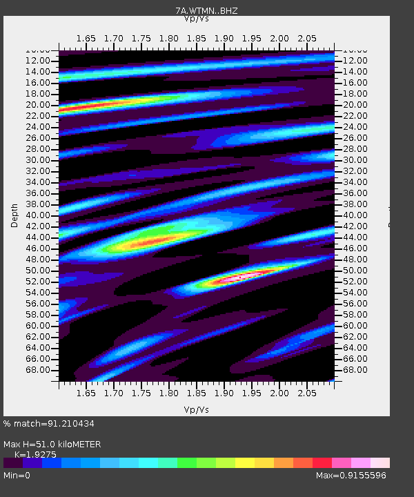
| Estimated Moho Depth: |
51.0 km |
| Estimated Crust Vp/Vs: |
1.93 |
| Assumed Crust Vp: |
6.159 km/s |
| Estimated Crust Vs: |
3.195 km/s |
| Estimated Crust Poisson's Ratio: |
0.32 |
|
| Radial Match: |
91.210434 % |
| Radial Bump: |
285 |
| Transverse Match: |
77.27872 % |
| Transverse Bump: |
400 |
| SOD ConfigId: |
11737051 |
| Insert Time: |
2019-04-25 01:18:03.347 +0000 |
| GWidth: |
2.5 |
| Max Bumps: |
400 |
| Tol: |
0.001 |
|

Signal To Noise
| Channel | StoN | STA | LTA |
| 7A:WTMN: :BHZ:20160711T02:07:52.290006Z | 12.90542 | 8.6488336E-7 | 6.701706E-8 |
| 7A:WTMN: :BHN:20160711T02:07:52.290006Z | 7.495305 | 5.50033E-7 | 7.338367E-8 |
| 7A:WTMN: :BHE:20160711T02:07:52.290006Z | 3.3419013 | 1.6380946E-7 | 4.9016844E-8 |
| Arrivals |
| Ps | 8.2 SECOND |
| PpPs | 23 SECOND |
| PsPs/PpSs | 31 SECOND |


