You are here: Home > Network List > AK - Alaska Regional Network Stations List
> Station BCP Bancas Point, AK, USA > Earthquake Result Viewer
BCP Bancas Point, AK, USA - Earthquake Result Viewer
| Earthquake location: |
Near Coast Of Ecuador |
| Earthquake latitude/longitude: |
0.6/-79.6 |
| Earthquake time(UTC): |
2016/07/11 (193) 02:01:09 GMT |
| Earthquake Depth: |
14 km |
| Earthquake Magnitude: |
5.8 MWW, 5.7 MWB, 5.9 MWC |
| Earthquake Catalog/Contributor: |
NEIC PDE/NEIC COMCAT |
|
| Network: |
AK Alaska Regional Network |
| Station: |
BCP Bancas Point, AK, USA |
| Lat/Lon: |
59.95 N/139.63 W |
| Elevation: |
422 m |
|
| Distance: |
74.9 deg |
| Az: |
333.172 deg |
| Baz: |
116.26 deg |
| Ray Param: |
0.0520052 |
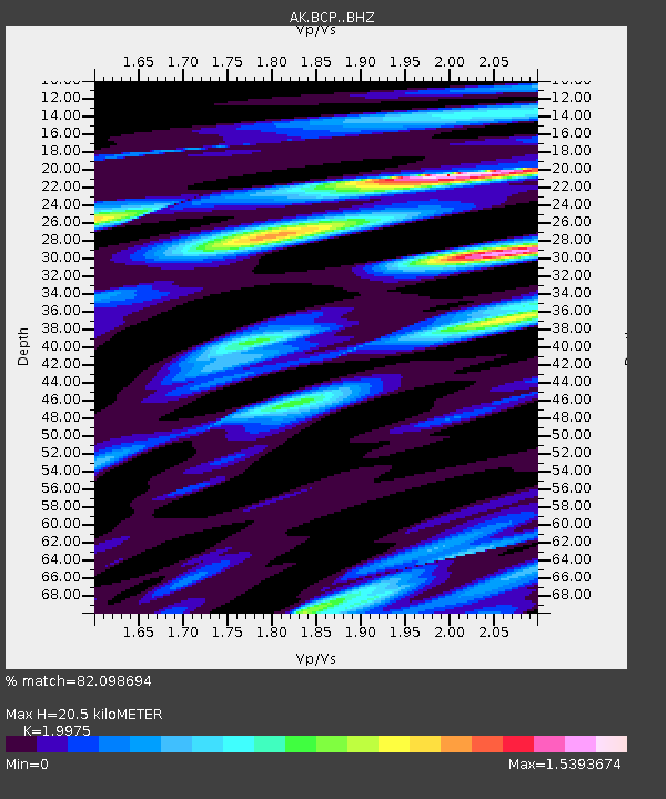
| Estimated Moho Depth: |
20.5 km |
| Estimated Crust Vp/Vs: |
2.00 |
| Assumed Crust Vp: |
6.183 km/s |
| Estimated Crust Vs: |
3.095 km/s |
| Estimated Crust Poisson's Ratio: |
0.33 |
|
| Radial Match: |
82.098694 % |
| Radial Bump: |
400 |
| Transverse Match: |
80.641655 % |
| Transverse Bump: |
400 |
| SOD ConfigId: |
11737051 |
| Insert Time: |
2019-04-25 01:18:17.989 +0000 |
| GWidth: |
2.5 |
| Max Bumps: |
400 |
| Tol: |
0.001 |
|

Signal To Noise
| Channel | StoN | STA | LTA |
| AK:BCP: :BHZ:20160711T02:12:18.468015Z | 10.0650425 | 6.5201095E-7 | 6.477975E-8 |
| AK:BCP: :BHN:20160711T02:12:18.468015Z | 2.2690952 | 2.4259492E-7 | 1.0691262E-7 |
| AK:BCP: :BHE:20160711T02:12:18.468015Z | 3.5981774 | 3.796021E-7 | 1.05498444E-7 |
| Arrivals |
| Ps | 3.4 SECOND |
| PpPs | 9.7 SECOND |
| PsPs/PpSs | 13 SECOND |


