You are here: Home > Network List > US - United States National Seismic Network Stations List
> Station HAWA Hanford, Washington, USA > Earthquake Result Viewer
HAWA Hanford, Washington, USA - Earthquake Result Viewer

| Earthquake location: |
Tonga Islands |
| Earthquake latitude/longitude: |
-21.9/-173.8 |
| Earthquake time(UTC): |
2008/10/19 (293) 05:10:33 GMT |
| Earthquake Depth: |
29 km |
| Earthquake Magnitude: |
6.8 MB, 7.0 MS, 6.9 MW, 6.9 MW |
| Earthquake Catalog/Contributor: |
WHDF/NEIC |
|
| Network: |
US United States National Seismic Network |
| Station: |
HAWA Hanford, Washington, USA |
| Lat/Lon: |
46.39 N/119.53 W |
| Elevation: |
364 m |
|
| Distance: |
83.8 deg |
| Az: |
34.423 deg |
| Baz: |
229.349 deg |
| Ray Param: |
0.04589807 |
| Estimated Moho Depth: |
39.0 km |
| Estimated Crust Vp/Vs: |
1.79 |
| Assumed Crust Vp: |
6.419 km/s |
| Estimated Crust Vs: |
3.581 km/s |
| Estimated Crust Poisson's Ratio: |
0.27 |
|
| Radial Match: |
96.049164 % |
| Radial Bump: |
400 |
| Transverse Match: |
85.331116 % |
| Transverse Bump: |
400 |
| SOD ConfigId: |
2556 |
| Insert Time: |
2010-03-05 05:10:41.390 +0000 |
| GWidth: |
2.5 |
| Max Bumps: |
400 |
| Tol: |
0.001 |
|
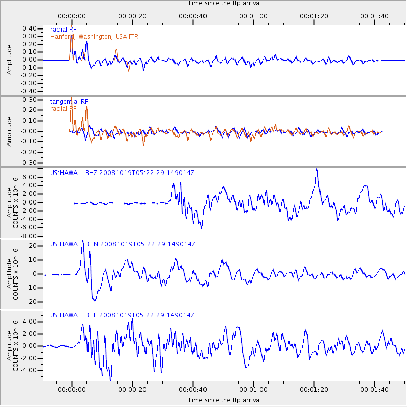
Signal To Noise
| Channel | StoN | STA | LTA |
| US:HAWA: :BHN:20081019T05:22:29.149014Z | 67.46556 | 9.057956E-6 | 1.3426045E-7 |
| US:HAWA: :BHE:20081019T05:22:29.149014Z | 14.269395 | 1.4563557E-6 | 1.02061485E-7 |
| US:HAWA: :BHZ:20081019T05:22:29.149014Z | 17.06731 | 1.8091681E-6 | 1.0600194E-7 |
| Arrivals |
| Ps | 4.9 SECOND |
| PpPs | 17 SECOND |
| PsPs/PpSs | 21 SECOND |


