You are here: Home > Network List > GS - US Geological Survey Networks Stations List
> Station ENG7 ASL Experiment > Earthquake Result Viewer
ENG7 ASL Experiment - Earthquake Result Viewer
| Earthquake location: |
Near Coast Of Ecuador |
| Earthquake latitude/longitude: |
0.6/-79.6 |
| Earthquake time(UTC): |
2016/07/11 (193) 02:01:09 GMT |
| Earthquake Depth: |
14 km |
| Earthquake Magnitude: |
5.8 MWW, 5.7 MWB, 5.9 MWC |
| Earthquake Catalog/Contributor: |
NEIC PDE/NEIC COMCAT |
|
| Network: |
GS US Geological Survey Networks |
| Station: |
ENG7 ASL Experiment |
| Lat/Lon: |
34.94 N/106.46 W |
| Elevation: |
1850 m |
|
| Distance: |
42.4 deg |
| Az: |
326.641 deg |
| Baz: |
137.986 deg |
| Ray Param: |
0.07320495 |
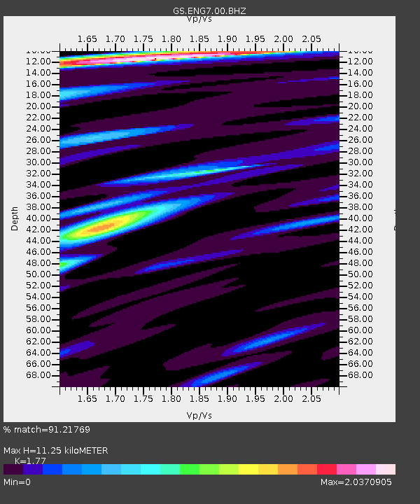
| Estimated Moho Depth: |
11.25 km |
| Estimated Crust Vp/Vs: |
1.77 |
| Assumed Crust Vp: |
6.502 km/s |
| Estimated Crust Vs: |
3.673 km/s |
| Estimated Crust Poisson's Ratio: |
0.27 |
|
| Radial Match: |
91.21769 % |
| Radial Bump: |
384 |
| Transverse Match: |
84.41615 % |
| Transverse Bump: |
400 |
| SOD ConfigId: |
11737051 |
| Insert Time: |
2019-04-25 01:22:28.692 +0000 |
| GWidth: |
2.5 |
| Max Bumps: |
400 |
| Tol: |
0.001 |
|

Signal To Noise
| Channel | StoN | STA | LTA |
| GS:ENG7:00:BHZ:20160711T02:08:32.26901Z | 5.014798 | 2.9593832E-7 | 5.9013008E-8 |
| GS:ENG7:00:BH1:20160711T02:08:32.26901Z | 5.838617 | 1.9333804E-7 | 3.3113672E-8 |
| GS:ENG7:00:BH2:20160711T02:08:32.26901Z | 2.7273498 | 1.1745273E-7 | 4.3064784E-8 |
| Arrivals |
| Ps | 1.4 SECOND |
| PpPs | 4.5 SECOND |
| PsPs/PpSs | 5.9 SECOND |


