You are here: Home > Network List > IM - International Miscellaneous Stations Stations List
> Station TKL Tuckaleechee Caverns, TN, USA > Earthquake Result Viewer
TKL Tuckaleechee Caverns, TN, USA - Earthquake Result Viewer
| Earthquake location: |
Near Coast Of Ecuador |
| Earthquake latitude/longitude: |
0.6/-79.6 |
| Earthquake time(UTC): |
2016/07/11 (193) 02:01:09 GMT |
| Earthquake Depth: |
14 km |
| Earthquake Magnitude: |
5.8 MWW, 5.7 MWB, 5.9 MWC |
| Earthquake Catalog/Contributor: |
NEIC PDE/NEIC COMCAT |
|
| Network: |
IM International Miscellaneous Stations |
| Station: |
TKL Tuckaleechee Caverns, TN, USA |
| Lat/Lon: |
35.66 N/83.77 W |
| Elevation: |
351 m |
|
| Distance: |
35.1 deg |
| Az: |
354.15 deg |
| Baz: |
172.811 deg |
| Ray Param: |
0.077380575 |
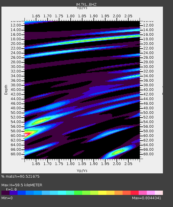
| Estimated Moho Depth: |
59.5 km |
| Estimated Crust Vp/Vs: |
1.60 |
| Assumed Crust Vp: |
6.35 km/s |
| Estimated Crust Vs: |
3.969 km/s |
| Estimated Crust Poisson's Ratio: |
0.18 |
|
| Radial Match: |
90.521675 % |
| Radial Bump: |
400 |
| Transverse Match: |
79.477104 % |
| Transverse Bump: |
400 |
| SOD ConfigId: |
11737051 |
| Insert Time: |
2019-04-25 01:22:45.522 +0000 |
| GWidth: |
2.5 |
| Max Bumps: |
400 |
| Tol: |
0.001 |
|

Signal To Noise
| Channel | StoN | STA | LTA |
| IM:TKL: :BHZ:20160711T02:07:31.51901Z | 10.4130745 | 8.7439264E-7 | 8.397065E-8 |
| IM:TKL: :BHN:20160711T02:07:31.51901Z | 9.097386 | 4.864315E-7 | 5.3469368E-8 |
| IM:TKL: :BHE:20160711T02:07:31.51901Z | 2.763262 | 1.2267893E-7 | 4.4396415E-8 |
| Arrivals |
| Ps | 6.1 SECOND |
| PpPs | 22 SECOND |
| PsPs/PpSs | 29 SECOND |


