You are here: Home > Network List > LD - Lamont-Doherty Cooperative Seismographic Network Stations List
> Station MVL Millersville University, PA > Earthquake Result Viewer
MVL Millersville University, PA - Earthquake Result Viewer
| Earthquake location: |
Near Coast Of Ecuador |
| Earthquake latitude/longitude: |
0.6/-79.6 |
| Earthquake time(UTC): |
2016/07/11 (193) 02:01:09 GMT |
| Earthquake Depth: |
14 km |
| Earthquake Magnitude: |
5.8 MWW, 5.7 MWB, 5.9 MWC |
| Earthquake Catalog/Contributor: |
NEIC PDE/NEIC COMCAT |
|
| Network: |
LD Lamont-Doherty Cooperative Seismographic Network |
| Station: |
MVL Millersville University, PA |
| Lat/Lon: |
40.00 N/76.35 W |
| Elevation: |
91 m |
|
| Distance: |
39.4 deg |
| Az: |
3.992 deg |
| Baz: |
185.2 deg |
| Ray Param: |
0.075021535 |
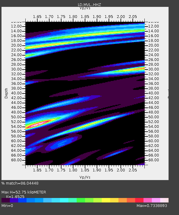
| Estimated Moho Depth: |
52.75 km |
| Estimated Crust Vp/Vs: |
1.65 |
| Assumed Crust Vp: |
6.419 km/s |
| Estimated Crust Vs: |
3.885 km/s |
| Estimated Crust Poisson's Ratio: |
0.21 |
|
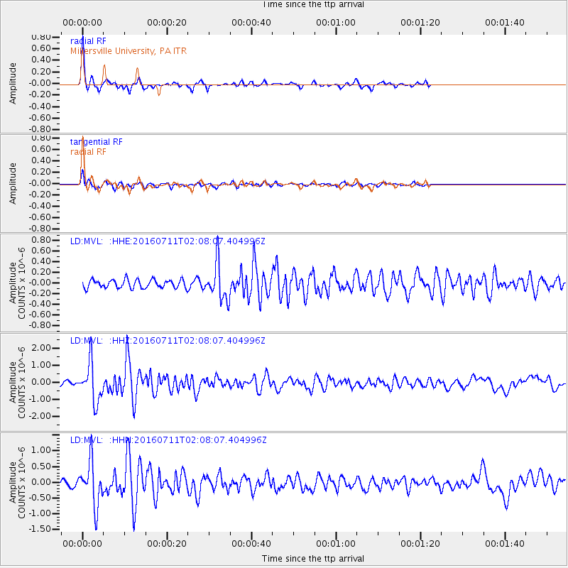
| Radial Match: |
86.04448 % |
| Radial Bump: |
227 |
| Transverse Match: |
74.483315 % |
| Transverse Bump: |
348 |
| SOD ConfigId: |
11737051 |
| Insert Time: |
2019-04-25 01:23:08.174 +0000 |
| GWidth: |
2.5 |
| Max Bumps: |
400 |
| Tol: |
0.001 |
|
Signal To Noise
| Channel | StoN | STA | LTA |
| LD:MVL: :HHZ:20160711T02:08:07.404996Z | 10.790993 | 1.1703942E-6 | 1.08460284E-7 |
| LD:MVL: :HHN:20160711T02:08:07.404996Z | 6.3038955 | 7.144413E-7 | 1.133333E-7 |
| LD:MVL: :HHE:20160711T02:08:07.404996Z | 4.414172 | 3.4732278E-7 | 7.868356E-8 |
| Arrivals |
| Ps | 5.8 SECOND |
| PpPs | 20 SECOND |
| PsPs/PpSs | 26 SECOND |


