You are here: Home > Network List > N4 - Central and EAstern US Network Stations List
> Station 451A Vernon, FL, USA > Earthquake Result Viewer
451A Vernon, FL, USA - Earthquake Result Viewer
| Earthquake location: |
Near Coast Of Ecuador |
| Earthquake latitude/longitude: |
0.6/-79.6 |
| Earthquake time(UTC): |
2016/07/11 (193) 02:01:09 GMT |
| Earthquake Depth: |
14 km |
| Earthquake Magnitude: |
5.8 MWW, 5.7 MWB, 5.9 MWC |
| Earthquake Catalog/Contributor: |
NEIC PDE/NEIC COMCAT |
|
| Network: |
N4 Central and EAstern US Network |
| Station: |
451A Vernon, FL, USA |
| Lat/Lon: |
30.62 N/85.75 W |
| Elevation: |
20 m |
|
| Distance: |
30.4 deg |
| Az: |
349.579 deg |
| Baz: |
167.889 deg |
| Ray Param: |
0.07932772 |
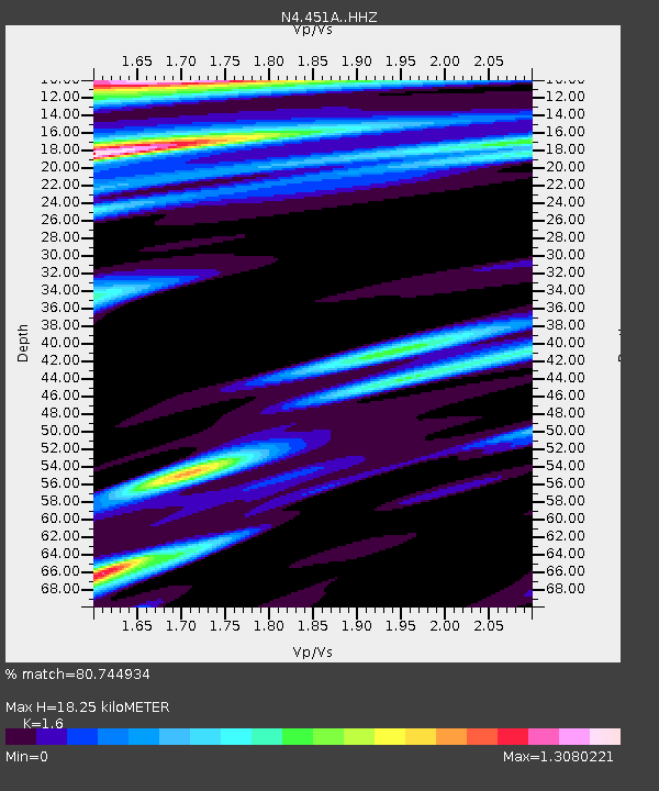
| Estimated Moho Depth: |
18.25 km |
| Estimated Crust Vp/Vs: |
1.60 |
| Assumed Crust Vp: |
6.347 km/s |
| Estimated Crust Vs: |
3.967 km/s |
| Estimated Crust Poisson's Ratio: |
0.18 |
|
| Radial Match: |
80.744934 % |
| Radial Bump: |
400 |
| Transverse Match: |
63.36683 % |
| Transverse Bump: |
400 |
| SOD ConfigId: |
11737051 |
| Insert Time: |
2019-04-25 01:23:35.905 +0000 |
| GWidth: |
2.5 |
| Max Bumps: |
400 |
| Tol: |
0.001 |
|

Signal To Noise
| Channel | StoN | STA | LTA |
| N4:451A: :HHZ:20160711T02:06:50.719999Z | 4.95833 | 1.1087851E-6 | 2.2362069E-7 |
| N4:451A: :HHN:20160711T02:06:50.719999Z | 2.3047347 | 5.6759296E-7 | 2.4627258E-7 |
| N4:451A: :HHE:20160711T02:06:50.719999Z | 1.8796426 | 2.8807364E-7 | 1.5325979E-7 |
| Arrivals |
| Ps | 1.9 SECOND |
| PpPs | 6.9 SECOND |
| PsPs/PpSs | 8.7 SECOND |


