You are here: Home > Network List > US - United States National Seismic Network Stations List
> Station HAWA Hanford, Washington, USA > Earthquake Result Viewer
HAWA Hanford, Washington, USA - Earthquake Result Viewer
| Earthquake location: |
Samoa Islands Region |
| Earthquake latitude/longitude: |
-16.6/-172.0 |
| Earthquake time(UTC): |
2006/09/28 (271) 06:22:09 GMT |
| Earthquake Depth: |
28 km |
| Earthquake Magnitude: |
6.5 MB, 6.6 MS, 6.9 MW, 6.7 MW |
| Earthquake Catalog/Contributor: |
WHDF/NEIC |
|
| Network: |
US United States National Seismic Network |
| Station: |
HAWA Hanford, Washington, USA |
| Lat/Lon: |
46.39 N/119.53 W |
| Elevation: |
364 m |
|
| Distance: |
78.5 deg |
| Az: |
34.079 deg |
| Baz: |
230.922 deg |
| Ray Param: |
0.04955675 |
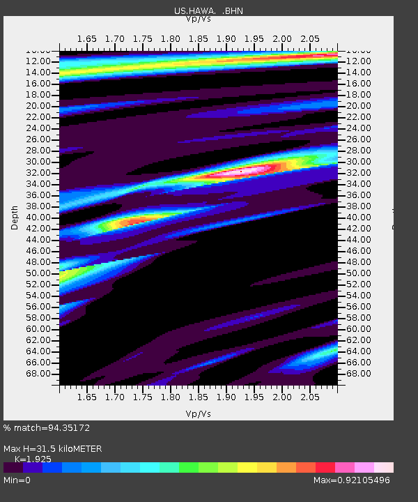
| Estimated Moho Depth: |
31.5 km |
| Estimated Crust Vp/Vs: |
1.92 |
| Assumed Crust Vp: |
6.419 km/s |
| Estimated Crust Vs: |
3.335 km/s |
| Estimated Crust Poisson's Ratio: |
0.32 |
|
| Radial Match: |
94.35172 % |
| Radial Bump: |
342 |
| Transverse Match: |
78.79691 % |
| Transverse Bump: |
399 |
| SOD ConfigId: |
2665 |
| Insert Time: |
2010-03-05 05:11:57.241 +0000 |
| GWidth: |
2.5 |
| Max Bumps: |
400 |
| Tol: |
0.001 |
|

Signal To Noise
| Channel | StoN | STA | LTA |
| US:HAWA: :BHN:20060928T06:33:37.12502Z | 7.819578 | 8.453685E-7 | 1.0810922E-7 |
| US:HAWA: :BHE:20060928T06:33:37.12502Z | 9.094365 | 9.056752E-7 | 9.958641E-8 |
| US:HAWA: :BHZ:20060928T06:33:37.12502Z | 22.306913 | 3.8504295E-6 | 1.726115E-7 |
| Arrivals |
| Ps | 4.7 SECOND |
| PpPs | 14 SECOND |
| PsPs/PpSs | 19 SECOND |


