You are here: Home > Network List > US - United States National Seismic Network Stations List
> Station HAWA Hanford, Washington, USA > Earthquake Result Viewer
HAWA Hanford, Washington, USA - Earthquake Result Viewer
| Earthquake location: |
Solomon Islands |
| Earthquake latitude/longitude: |
-6.8/155.5 |
| Earthquake time(UTC): |
2006/09/01 (244) 10:18:51 GMT |
| Earthquake Depth: |
38 km |
| Earthquake Magnitude: |
6.3 MB, 6.7 MS, 6.8 MW, 6.7 MW |
| Earthquake Catalog/Contributor: |
WHDF/NEIC |
|
| Network: |
US United States National Seismic Network |
| Station: |
HAWA Hanford, Washington, USA |
| Lat/Lon: |
46.39 N/119.53 W |
| Elevation: |
364 m |
|
| Distance: |
91.4 deg |
| Az: |
43.603 deg |
| Baz: |
261.721 deg |
| Ray Param: |
0.041601744 |
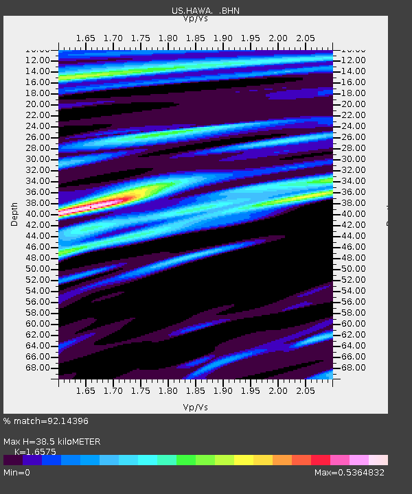
| Estimated Moho Depth: |
38.5 km |
| Estimated Crust Vp/Vs: |
1.66 |
| Assumed Crust Vp: |
6.419 km/s |
| Estimated Crust Vs: |
3.873 km/s |
| Estimated Crust Poisson's Ratio: |
0.21 |
|
| Radial Match: |
92.14396 % |
| Radial Bump: |
400 |
| Transverse Match: |
65.81145 % |
| Transverse Bump: |
400 |
| SOD ConfigId: |
2665 |
| Insert Time: |
2010-03-05 05:11:58.556 +0000 |
| GWidth: |
2.5 |
| Max Bumps: |
400 |
| Tol: |
0.001 |
|
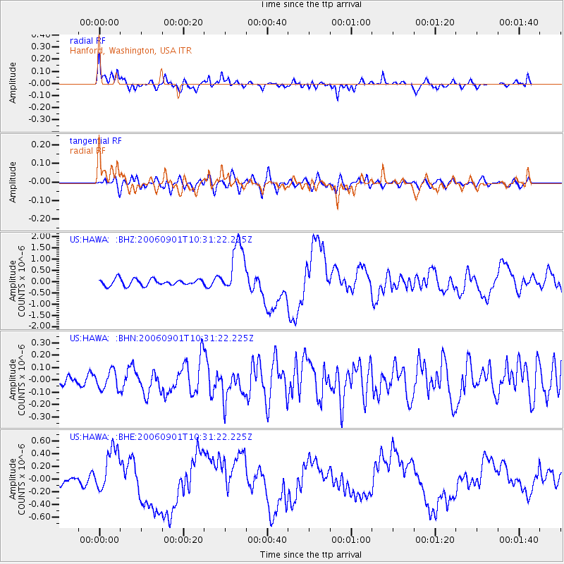
Signal To Noise
| Channel | StoN | STA | LTA |
| US:HAWA: :BHN:20060901T10:31:22.225Z | 0.84975135 | 7.44603E-8 | 8.762599E-8 |
| US:HAWA: :BHE:20060901T10:31:22.225Z | 6.976481 | 3.6235258E-7 | 5.1939164E-8 |
| US:HAWA: :BHZ:20060901T10:31:22.225Z | 8.29296 | 1.1745939E-6 | 1.4163747E-7 |
| Arrivals |
| Ps | 4.0 SECOND |
| PpPs | 16 SECOND |
| PsPs/PpSs | 20 SECOND |


