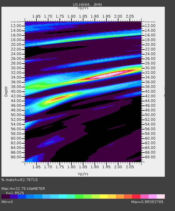
HAWA Hanford, Washington, USA - Earthquake Result Viewer

Earthquake location: Rat Islands, Aleutian Islands
Earthquake latitude/longitude: 51.8/177.1
Earthquake time(UTC): 2006/06/14 (165) 04:18:42 GMT
Earthquake Depth: 14 km
Earthquake Magnitude: 5.9 MB, 6.4 MS, 6.4 MW, 6.4 MW
Earthquake Catalog/Contributor: WHDF/NEIC
Network: US United States National Seismic Network
Station: HAWA Hanford, Washington, USA
Lat/Lon: 46.39 N/119.53 W
Elevation: 364 m
Distance: 40.7 deg
Az: 71.605 deg
Baz: 301.544 deg
Ray Param: 0.074236095
Estimated Moho Depth: 32.75 km
Estimated Crust Vp/Vs: 1.95
Assumed Crust Vp: 6.419 km/s
Estimated Crust Vs: 3.288 km/s
Estimated Crust Poisson's Ratio: 0.32
Radial Match: 92.79718 %
Radial Bump: 326
Transverse Match: 67.274864 %
Transverse Bump: 400
SOD ConfigId: 5745
Insert Time: 2010-03-05 05:12:14.477 +0000
GWidth: 2.5
Max Bumps: 400
Tol: 0.001

Signal To Noise

ChannelStoNSTALTA
US:HAWA: :BHN:20060614T04:25:51.650015Z1.50358411.7478206E-71.16243626E-7
US:HAWA: :BHE:20060614T04:25:51.650015Z1.84346272.550952E-71.3837827E-7
US:HAWA: :BHZ:20060614T04:25:51.650015Z2.9910755.129242E-71.714849E-7
Arrivals
Ps5.2 SECOND
PpPs14 SECOND
PsPs/PpSs19 SECOND