You are here: Home > Network List > N4 - Central and EAstern US Network Stations List
> Station P43A Skaggs, Pawnee, IL, USA > Earthquake Result Viewer
P43A Skaggs, Pawnee, IL, USA - Earthquake Result Viewer
| Earthquake location: |
Near Coast Of Ecuador |
| Earthquake latitude/longitude: |
0.6/-79.6 |
| Earthquake time(UTC): |
2016/07/11 (193) 02:01:09 GMT |
| Earthquake Depth: |
14 km |
| Earthquake Magnitude: |
5.8 MWW, 5.7 MWB, 5.9 MWC |
| Earthquake Catalog/Contributor: |
NEIC PDE/NEIC COMCAT |
|
| Network: |
N4 Central and EAstern US Network |
| Station: |
P43A Skaggs, Pawnee, IL, USA |
| Lat/Lon: |
39.64 N/89.52 W |
| Elevation: |
176 m |
|
| Distance: |
39.9 deg |
| Az: |
348.089 deg |
| Baz: |
164.497 deg |
| Ray Param: |
0.07469143 |
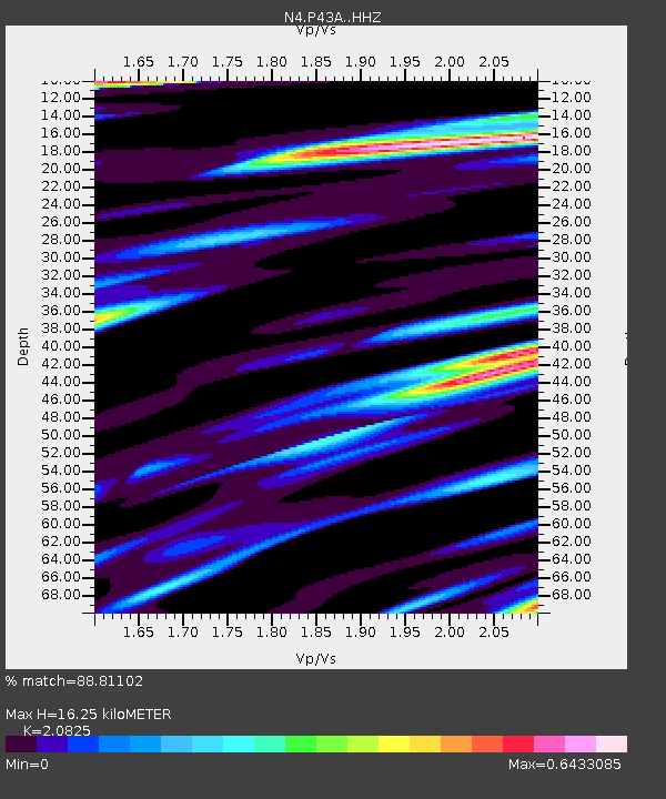
| Estimated Moho Depth: |
16.25 km |
| Estimated Crust Vp/Vs: |
2.08 |
| Assumed Crust Vp: |
6.444 km/s |
| Estimated Crust Vs: |
3.094 km/s |
| Estimated Crust Poisson's Ratio: |
0.35 |
|
| Radial Match: |
88.81102 % |
| Radial Bump: |
266 |
| Transverse Match: |
71.31875 % |
| Transverse Bump: |
400 |
| SOD ConfigId: |
11737051 |
| Insert Time: |
2019-04-25 01:24:36.569 +0000 |
| GWidth: |
2.5 |
| Max Bumps: |
400 |
| Tol: |
0.001 |
|

Signal To Noise
| Channel | StoN | STA | LTA |
| N4:P43A: :HHZ:20160711T02:08:12.080015Z | 10.4492035 | 9.097891E-7 | 8.706779E-8 |
| N4:P43A: :HHN:20160711T02:08:12.080015Z | 6.328947 | 4.9596457E-7 | 7.836447E-8 |
| N4:P43A: :HHE:20160711T02:08:12.080015Z | 3.147204 | 2.3032516E-7 | 7.318406E-8 |
| Arrivals |
| Ps | 2.9 SECOND |
| PpPs | 7.3 SECOND |
| PsPs/PpSs | 10 SECOND |


