You are here: Home > Network List > CO - South Carolina Seismic Network Stations List
> Station PAULI Pauline, SC, USA > Earthquake Result Viewer
PAULI Pauline, SC, USA - Earthquake Result Viewer
| Earthquake location: |
Near Coast Of Central Chile |
| Earthquake latitude/longitude: |
-31.6/-71.8 |
| Earthquake time(UTC): |
2015/09/16 (259) 22:54:31 GMT |
| Earthquake Depth: |
12 km |
| Earthquake Magnitude: |
8.3 MWW, 7.9 MI |
| Earthquake Catalog/Contributor: |
NEIC PDE/NEIC COMCAT |
|
| Network: |
CO South Carolina Seismic Network |
| Station: |
PAULI Pauline, SC, USA |
| Lat/Lon: |
34.82 N/81.81 W |
| Elevation: |
179 m |
|
| Distance: |
66.7 deg |
| Az: |
350.997 deg |
| Baz: |
170.658 deg |
| Ray Param: |
0.05741974 |
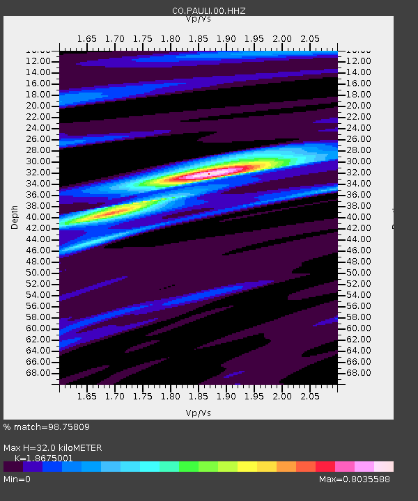
| Estimated Moho Depth: |
32.0 km |
| Estimated Crust Vp/Vs: |
1.87 |
| Assumed Crust Vp: |
6.419 km/s |
| Estimated Crust Vs: |
3.437 km/s |
| Estimated Crust Poisson's Ratio: |
0.30 |
|
| Radial Match: |
98.75809 % |
| Radial Bump: |
182 |
| Transverse Match: |
91.740395 % |
| Transverse Bump: |
400 |
| SOD ConfigId: |
1156111 |
| Insert Time: |
2015-09-30 23:14:35.946 +0000 |
| GWidth: |
2.5 |
| Max Bumps: |
400 |
| Tol: |
0.001 |
|

Signal To Noise
| Channel | StoN | STA | LTA |
| CO:PAULI:00:HHZ:20150916T23:04:50.860007Z | 12.328876 | 2.5087659E-6 | 2.0348699E-7 |
| CO:PAULI:00:HHN:20150916T23:04:50.860007Z | 8.568994 | 1.0670394E-6 | 1.2452331E-7 |
| CO:PAULI:00:HHE:20150916T23:04:50.860007Z | 1.2282658 | 1.948354E-7 | 1.586264E-7 |
| Arrivals |
| Ps | 4.5 SECOND |
| PpPs | 14 SECOND |
| PsPs/PpSs | 18 SECOND |


