You are here: Home > Network List > N4 - Central and EAstern US Network Stations List
> Station W45B Hickory Valley, TN, USA > Earthquake Result Viewer
W45B Hickory Valley, TN, USA - Earthquake Result Viewer
| Earthquake location: |
Near Coast Of Ecuador |
| Earthquake latitude/longitude: |
0.6/-79.6 |
| Earthquake time(UTC): |
2016/07/11 (193) 02:01:09 GMT |
| Earthquake Depth: |
14 km |
| Earthquake Magnitude: |
5.8 MWW, 5.7 MWB, 5.9 MWC |
| Earthquake Catalog/Contributor: |
NEIC PDE/NEIC COMCAT |
|
| Network: |
N4 Central and EAstern US Network |
| Station: |
W45B Hickory Valley, TN, USA |
| Lat/Lon: |
35.16 N/89.19 W |
| Elevation: |
182 m |
|
| Distance: |
35.5 deg |
| Az: |
346.488 deg |
| Baz: |
163.433 deg |
| Ray Param: |
0.0771588 |
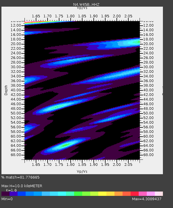
| Estimated Moho Depth: |
10.0 km |
| Estimated Crust Vp/Vs: |
1.60 |
| Assumed Crust Vp: |
6.38 km/s |
| Estimated Crust Vs: |
3.988 km/s |
| Estimated Crust Poisson's Ratio: |
0.18 |
|
| Radial Match: |
81.776665 % |
| Radial Bump: |
370 |
| Transverse Match: |
82.64886 % |
| Transverse Bump: |
400 |
| SOD ConfigId: |
11737051 |
| Insert Time: |
2019-04-25 01:25:10.774 +0000 |
| GWidth: |
2.5 |
| Max Bumps: |
400 |
| Tol: |
0.001 |
|

Signal To Noise
| Channel | StoN | STA | LTA |
| N4:W45B: :HHZ:20160711T02:07:35.149991Z | 10.6565485 | 8.20761E-7 | 7.70194E-8 |
| N4:W45B: :HHN:20160711T02:07:35.149991Z | 5.729 | 1.1354585E-6 | 1.9819488E-7 |
| N4:W45B: :HHE:20160711T02:07:35.149991Z | 3.0844736 | 5.523002E-7 | 1.7905818E-7 |
| Arrivals |
| Ps | 1.0 SECOND |
| PpPs | 3.8 SECOND |
| PsPs/PpSs | 4.8 SECOND |


