You are here: Home > Network List > US - United States National Seismic Network Stations List
> Station HAWA Hanford, Washington, USA > Earthquake Result Viewer
HAWA Hanford, Washington, USA - Earthquake Result Viewer

| Earthquake location: |
Central East Pacific Rise |
| Earthquake latitude/longitude: |
-4.1/-104.5 |
| Earthquake time(UTC): |
2001/06/26 (177) 12:33:52 GMT |
| Earthquake Depth: |
10 km |
| Earthquake Magnitude: |
5.0 MB, 5.8 MS, 6.0 MW, 6.0 MW |
| Earthquake Catalog/Contributor: |
WHDF/NEIC |
|
| Network: |
US United States National Seismic Network |
| Station: |
HAWA Hanford, Washington, USA |
| Lat/Lon: |
46.39 N/119.53 W |
| Elevation: |
364 m |
|
| Distance: |
52.0 deg |
| Az: |
346.803 deg |
| Baz: |
160.79 deg |
| Ray Param: |
0.06704994 |
| Estimated Moho Depth: |
10.0 km |
| Estimated Crust Vp/Vs: |
1.60 |
| Assumed Crust Vp: |
6.419 km/s |
| Estimated Crust Vs: |
4.012 km/s |
| Estimated Crust Poisson's Ratio: |
0.18 |
|
| Radial Match: |
99.999985 % |
| Radial Bump: |
2 |
| Transverse Match: |
99.99975 % |
| Transverse Bump: |
2 |
| SOD ConfigId: |
110165 |
| Insert Time: |
2010-03-05 05:12:40.338 +0000 |
| GWidth: |
2.5 |
| Max Bumps: |
400 |
| Tol: |
0.001 |
|
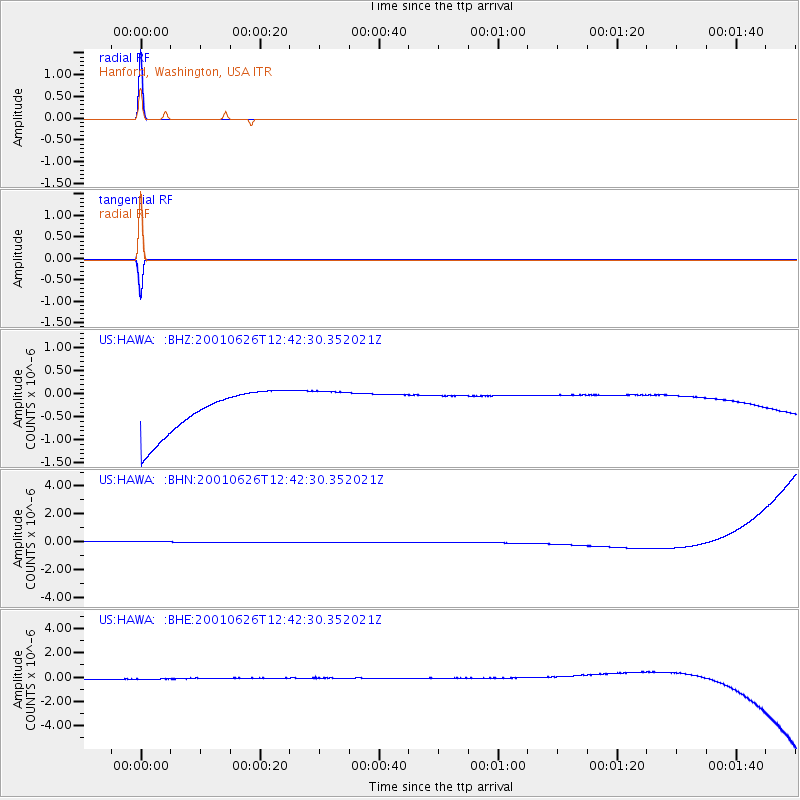
Signal To Noise
| Channel | StoN | STA | LTA |
| US:HAWA: :BHN:20010626T12:42:30.352021Z | 0.91906524 | 3.6709883E-7 | 3.994263E-7 |
| US:HAWA: :BHE:20010626T12:42:30.352021Z | 0.9040018 | 4.2515552E-7 | 4.7030386E-7 |
| US:HAWA: :BHZ:20010626T12:42:30.352021Z | 0.90573066 | 4.2755667E-7 | 4.720572E-7 |
| Arrivals |
| Ps | 1.0 SECOND |
| PpPs | 3.8 SECOND |
| PsPs/PpSs | 4.8 SECOND |


