You are here: Home > Network List > US - United States National Seismic Network Stations List
> Station HAWA Hanford, Washington, USA > Earthquake Result Viewer
HAWA Hanford, Washington, USA - Earthquake Result Viewer
| Earthquake location: |
Near Coast Of Peru |
| Earthquake latitude/longitude: |
-16.3/-73.6 |
| Earthquake time(UTC): |
2001/06/23 (174) 20:33:14 GMT |
| Earthquake Depth: |
33 km |
| Earthquake Magnitude: |
6.7 MB, 8.2 MS, 8.4 MW, 7.8 ME |
| Earthquake Catalog/Contributor: |
WHDF/NEIC |
|
| Network: |
US United States National Seismic Network |
| Station: |
HAWA Hanford, Washington, USA |
| Lat/Lon: |
46.39 N/119.53 W |
| Elevation: |
364 m |
|
| Distance: |
74.8 deg |
| Az: |
329.007 deg |
| Baz: |
134.392 deg |
| Ray Param: |
0.052026823 |
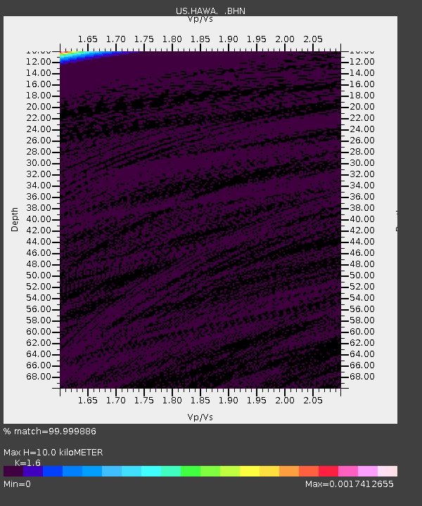
| Estimated Moho Depth: |
10.0 km |
| Estimated Crust Vp/Vs: |
1.60 |
| Assumed Crust Vp: |
6.419 km/s |
| Estimated Crust Vs: |
4.012 km/s |
| Estimated Crust Poisson's Ratio: |
0.18 |
|
| Radial Match: |
99.999886 % |
| Radial Bump: |
2 |
| Transverse Match: |
99.97132 % |
| Transverse Bump: |
3 |
| SOD ConfigId: |
110165 |
| Insert Time: |
2010-03-05 05:12:45.888 +0000 |
| GWidth: |
2.5 |
| Max Bumps: |
400 |
| Tol: |
0.001 |
|

Signal To Noise
| Channel | StoN | STA | LTA |
| US:HAWA: :BHN:20010623T20:44:20.176021Z | 0.8838896 | 3.6082758E-7 | 4.0822698E-7 |
| US:HAWA: :BHE:20010623T20:44:20.176021Z | 0.9367997 | 4.2876553E-7 | 4.576918E-7 |
| US:HAWA: :BHZ:20010623T20:44:20.176021Z | 0.901611 | 4.2279666E-7 | 4.6893467E-7 |
| Arrivals |
| Ps | 1.0 SECOND |
| PpPs | 3.9 SECOND |
| PsPs/PpSs | 4.9 SECOND |


