You are here: Home > Network List > PE - Penn State Network Stations List
> Station PSWB Penn State Wilkes-Barre > Earthquake Result Viewer
PSWB Penn State Wilkes-Barre - Earthquake Result Viewer
| Earthquake location: |
Near Coast Of Ecuador |
| Earthquake latitude/longitude: |
0.6/-79.6 |
| Earthquake time(UTC): |
2016/07/11 (193) 02:01:09 GMT |
| Earthquake Depth: |
14 km |
| Earthquake Magnitude: |
5.8 MWW, 5.7 MWB, 5.9 MWC |
| Earthquake Catalog/Contributor: |
NEIC PDE/NEIC COMCAT |
|
| Network: |
PE Penn State Network |
| Station: |
PSWB Penn State Wilkes-Barre |
| Lat/Lon: |
41.31 N/76.02 W |
| Elevation: |
398 m |
|
| Distance: |
40.7 deg |
| Az: |
4.197 deg |
| Baz: |
185.574 deg |
| Ray Param: |
0.07424981 |
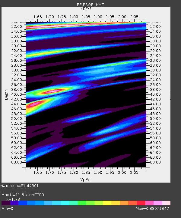
| Estimated Moho Depth: |
11.5 km |
| Estimated Crust Vp/Vs: |
1.73 |
| Assumed Crust Vp: |
6.121 km/s |
| Estimated Crust Vs: |
3.538 km/s |
| Estimated Crust Poisson's Ratio: |
0.25 |
|
| Radial Match: |
81.44901 % |
| Radial Bump: |
263 |
| Transverse Match: |
82.52917 % |
| Transverse Bump: |
400 |
| SOD ConfigId: |
11737051 |
| Insert Time: |
2019-04-25 01:26:39.502 +0000 |
| GWidth: |
2.5 |
| Max Bumps: |
400 |
| Tol: |
0.001 |
|

Signal To Noise
| Channel | StoN | STA | LTA |
| PE:PSWB: :HHZ:20160711T02:08:18.399991Z | 9.313787 | 1.3699527E-6 | 1.4708867E-7 |
| PE:PSWB: :HHN:20160711T02:08:18.399991Z | 6.6594505 | 5.983316E-7 | 8.984699E-8 |
| PE:PSWB: :HHE:20160711T02:08:18.399991Z | 1.0756589 | 1.0564562E-7 | 9.821479E-8 |
| Arrivals |
| Ps | 1.5 SECOND |
| PpPs | 4.8 SECOND |
| PsPs/PpSs | 6.3 SECOND |


